• JOURNAL
  • Shows
  • CO-LAB
  • About
  • Contact
Menu

Terratory Journal

  • JOURNAL
  • Shows
  • CO-LAB
  • About
  • Contact
JOURNAL ARCHIVE
+YTown Map .6-2_800.jpg
STEPHEN CHALMERS: The Incredible Shrinking City
Read More →
_MG_0404.jpg
THIEU RIEMEN - Atmosphere in Agriculture
Read More →
1509_16_worked.jpg
COREY ARNOLD - Talking Tides
Read More →
BRUCE PARKER - On The Beach Manzanita
Read More →
Braquenier5.jpg
PHILLIPPE BRAQUENIER - Boundaries
Read More →
HARVEY WANG: Remembering Adam Purple
Read More →
Untitled-(Southern-California),-2013-(3).jpg
JUSTIN CLIFFORD RHODY - Land of Enchantment
Read More →
7.Encounter.21.0006.jpg
EDGELAND SPACE: Jennifer Colten
Read More →
Sandmotor-01.jpg
LAND THIEVES: A war on rising tides
Read More →
RUINS: Post-Industrial Society
Read More →
UTILITY POLES: Above or Below?
Read More →
Hwy_63_at_Broadway.jpg
BILLBOARDS: Your Ad Here
Read More →
Corner-of-33rd-and-Edsel-Ford-W,-Detroit-2015_6589359.jpg
DETROIT: Ruralized
Read More →
PHOTOBOOKS: The Golden Age
Read More →
4558-3(R).JPG
SENSE OF PLACE: Tanya Traboulsi
Read More →
Diptych 1 - Ave.H/ Rd. 120, East Lancaster, CA.
IMAGE AESTHETICS: trash or transcendental?
Read More →
MALCOLM KENYON - Calendula Fields
Read More →
CARDINAL DIRECTIONS
Read More →
State_border_1.jpg
BORDERS: Invisible Lines
Read More →
Picket-Line_1.png
URBAN DILEMMAS: What stays and what goes?
Read More →
ROBERT ADAMS: Talks Photography & Environment
Read More →
jackson_cups003.jpg
GREENSPACE: Your happiness depends on it!
Read More →
SHIFT: Rethinking Cars in the City
Read More →
AMERICAN SOUTHWEST: Bone-Dry!
Read More →
DAVE IMUS: The State of U.S. Mapmaking
Read More →
+YTown Map .6-2_800.jpg No_GPS-37.jpg GPS_41°3'52- N 80°39'30- W-2.jpg GPS_41°4'13- N 80°38'50- W-2.jpg GPS_41°3'52- N 80°39'32- W-3.jpg GPS_41°4'4- N 80°39'33- W-2.jpg GPS_41°3'58- N 80°39'32- W-2.jpg GPS_41°4'14- N 80°40'21- W-2.jpg GPS_41°5'7- N 80°39'16- W-2.jpg GPS_41°4'13- N 80°38'60- W-2.jpg GPS_41°4'1- N 80°39'35- W-2.jpg GPS_41°4'27- N 80°40'27- W-2.jpg GPS_41°4'25- N 80°40'36- W-2.jpg GPS_41°4'45- N 80°38'13- W.jpg GPS_41°3'48- N 80°39'16- W-2.jpg GPS_41°5'0- N 80°39'13- W-2.jpg GPS_41°5'12- N 80°39'39- W.jpg GPS_41°5'26- N 80°37'54- W.jpg GPS_41°6'5- N 80°37'58- W.jpg GPS_41°7'10- N 80°36'3- W.jpg GPS_41°7'34- N 80°38'38- W.jpg GPS_41°5'1- N 80°38'57- W-2-2.jpg No_GPS-18.jpg No_GPS-20.jpg GPS_41°3'59- N 80°39'35- W-2.jpg GPS_41°3'51- N 80°39'31- W-2-2.jpg GPS_41°4'5- N 80°40'21- W-2-2.jpg GPS_41°4'10- N 80°40'6- W-2-2.jpg GPS_41°5'7- N 80°39'12- W-2.jpg GPS_41°3'58- N 80°39'47- W.jpg GPS_41°4'6- N 80°39'30- W.jpg GPS_41°4'14- N 80°36'58- W-2.jpg GPS_41°4'36- N 80°37'33- W-2.jpg GPS_41°4'29- N 80°37'55- W-2.jpg GPS_41°6'46- N 80°38'22- W.jpg GPS_41°4'9- N 80°39'21- W.jpg GPS_41°4'41- N 80°38'30- W-2.jpg GPS_41°4'16- N 80°36'58- W-3.jpg GPS_41°4'48- N 80°38'39- W-2-2.jpg GPS_41°4'49- N 80°39'57- W.jpg GPS_41°4'51- N 80°38'4- W-2.jpg GPS_41°4'49- N 80°39'59- W-3.jpg GPS_41°4'56- N 80°39'56- W.jpg GPS_41°4'57- N 80°38'40- W-2.jpg GPS_41°5'8- N 80°38'50- W-2-2.jpg GPS_41°5'11- N 80°39'10- W.jpg GPS_41°4'60- N 80°38'41- W-2.jpg GPS_41°5'1- N 80°39'4- W.jpg GPS_41°5'4- N 80°39'15- W-2.jpg GPS_41°5'8- N 80°39'57- W.jpg GPS_41°5'11- N 80°39'7- W.jpg GPS_41°5'37- N 80°37'37- W.jpg GPS_41°5'47- N 80°39'53- W.jpg No_GPS-30.jpg GPS_41°7'6- N 80°40'15- W.jpg GPS_41°5'60- N 80°37'51- W.jpg No_GPS-61.jpg No_GPS-25.jpg GPS_41°6'36- N 80°40'54- W.jpg No_GPS-56.jpg GPS_41°6'40- N 80°34'51- W.jpg GPS_41°7'5- N 80°37'17- W.jpg No_GPS-24.jpg GPS_41°6'24- N 80°40'54- W.jpg

STEPHEN CHALMERS: The Incredible Shrinking City

July 23, 2016

Images By: Stephen Chalmers


Written by: Ryan Nemeth

A city can be defined as a large and permanent human settlement that is a hub of population, commerce and culture. Thus, cities have always functioned as resource centers for human beings and it follows that modern civilization is deeply intertwined with urban activity.  In fact, many of the world’s great universities, libraries, cathedrals, and museums are the result of human collaboration and innovation enabled by urban environments.  Make no mistake that humans have readily picked up on the explicit and implicit benefits of life in the city.  This is evidenced by humans’ massive migratory shift from a predominantly rural existence to one that is largely urban. At the turn of the nineteenth century, just two percent of the world’s one billion human inhabitants lived in cities. As of 2015, nearly 60 percent of the world’s 6.7 billion people currently live in cities. By 2050, this number is projected to be as much as 75 percent of the world’s 8.5 billion inhabitants. Given this statistic, one might easily assume steady global growth patterns for cities both large and small. However, something entirely different and somewhat paradoxical is happening.

Many cities are demonstrating significant population declines as others continue to thrive and grow. In fact, between 1950 and 2000, as many as 350 large global cities showed significant or stagnant declining population growth rates. Better yet, during the 1990s, more than a quarter of the world’s large cities receded.  What is more surprising is that these trends seem to be prevalent in countries with expanding economies.  Countries such as the USA, China, Germany, Japan, Korea, Finland, Belgium, Italy and Russia have noted recent and significant downward growth trends peppered throughout urban centers.  In many cases, these numbers are driven by changes or events that challenge the utilization of human capital. For example, in Eastern European countries and China, new labor and migration patterns have been driven by the introduction of capitalist economies.  Here in the States, our transition to a service economy has heightened labor migration.  The truth is that the rationale for the global “Shrinking Cities” phenomenon remains varied, however, many of the symptoms and ills associated with contraction are quite similar irrelevant of geography. Although these global declining growth patterns have long been identified, a 2002 German project creatively titled "Shrinking Cities" was the first to coin the term explaining this worldwide trend.

The “Shrinking Cities” project was initiated by the German Federal Cultural Foundation and the architecture magazine Archplus in response to shifting migratory patterns in Germany. More specifically, the fall of the Berlin wall in 1989 led to more than a million empty apartments and to the abandoning of countless industrial parks and social and cultural facilities in Eastern Germany. Thus, the “Shrinking Cities” project was initiated as an attempt to research and understand key drivers and relevant solutions to urban decline within Germany and abroad. Outside of Deutschland, the Shrinking Cities International (SCI) project gathered four interdisciplinary teams to study shrinking cities abroad, these cities include: Detroit, Mich.; Manchester and Liverpool, England; Ivanovo, Russia; and Halle and Leipzig, Germany. The broader research gathered by the SCI has led to insightful discoveries and collaboration while precipitating more activity on the topic of urban shrinkage. Here in the States, urban studies researchers, including those at the Institute of Urban and Regional Development at the University of California, Berkeley, have followed suite by creating a “Shrinking Cities” group of their own.

It is important to note that the “Shrinking Cities” concept contradicts the traditional industrial “Boomtown” image of a big city that is characterized by constant economic and demographic growth. Shrunken cities often spur a reconsideration of the economic, social and cultural benefits that serve as human attractors to the modern city. In many cases, people simply leave as opportunities and city resources diminish. To date, many cities with “Shrinkage” have demonstrated resistance to traditional urban planning solutions as the fixes go well beyond simply creating new jobs and reallocating resources.  Many shrinkage dilemmas are driven by widespread resource constraints that spill over into social and cultural issues within the urban core and municipality. What follows from the scarcity often yields environments whereby there are competing and conflicting interests for highly limited resources. Furthermore, and most importantly, these limitations are forcing planners and municipalities to allocate their services in unfamiliar environments and under new and challenging circumstances.  As new cities arise from the ashes, shrinking municipalities will increasingly be forced to serve community needs with non-traditional methods utilizing creative solutions.  This need for adaptation has proved to be a very tough proposition for many municipalities. In the case of Youngstown, OH and Detroit, MI, city planners have lagged well behind their stated goals and intentions for cleanup.

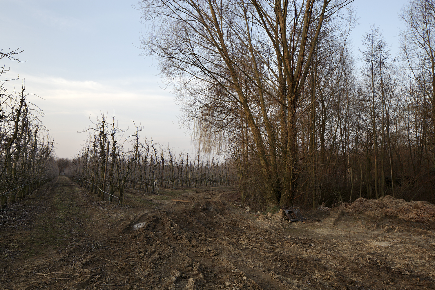
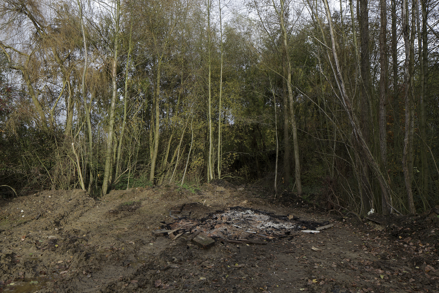
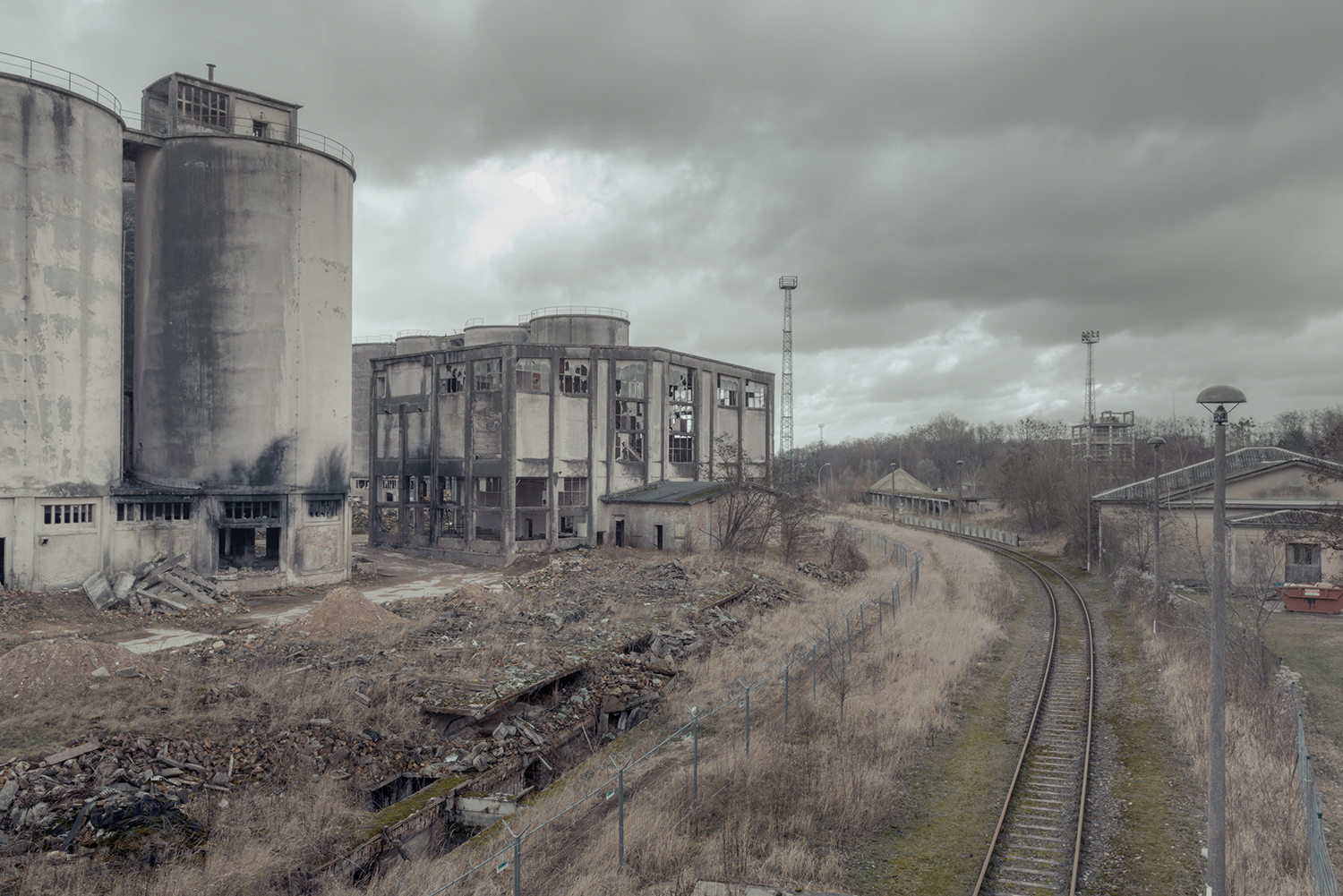
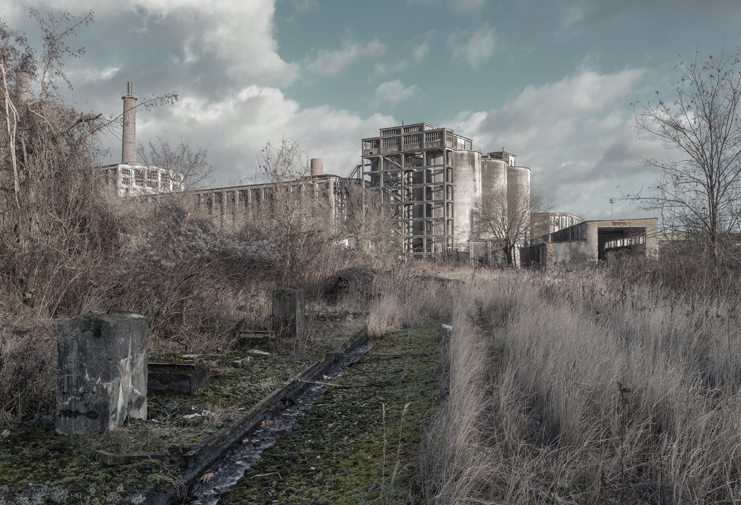
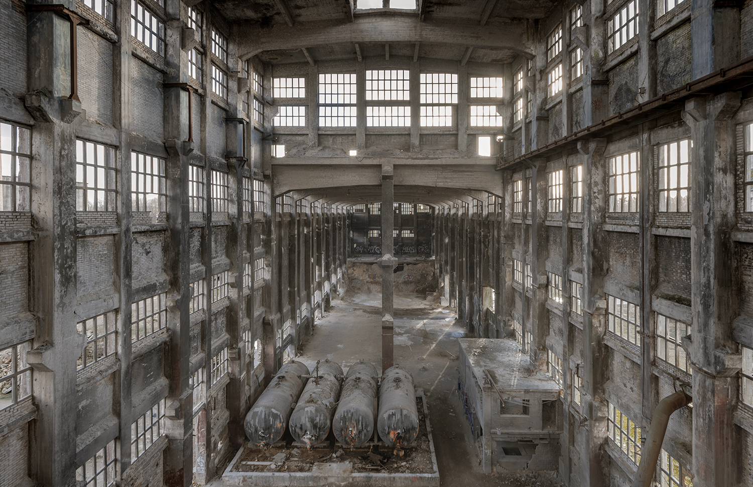
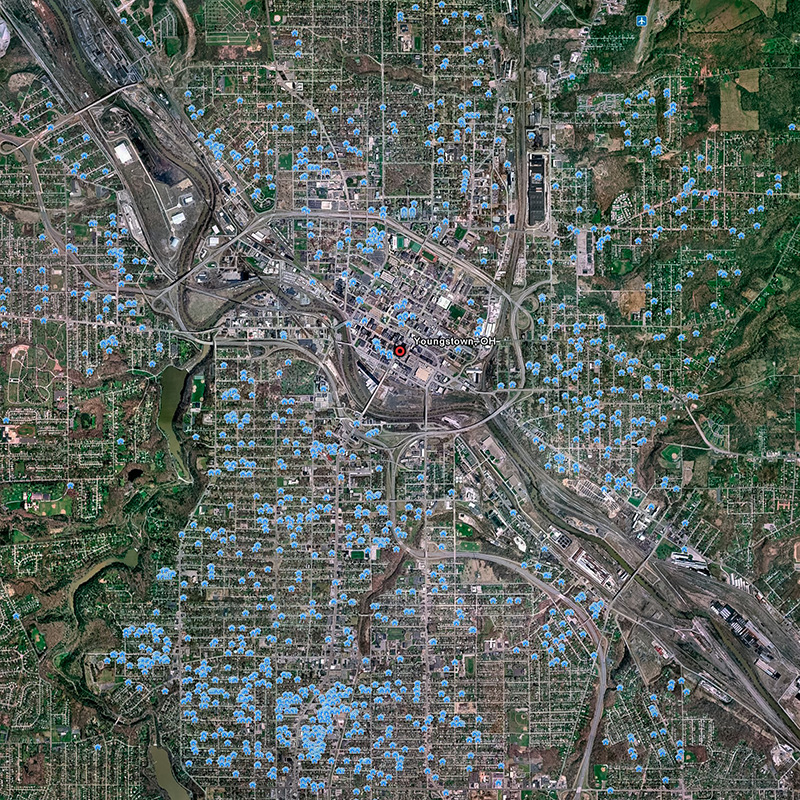
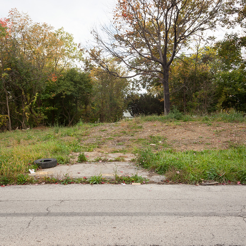
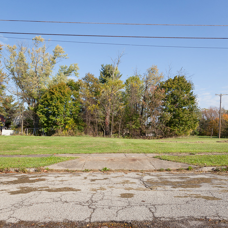
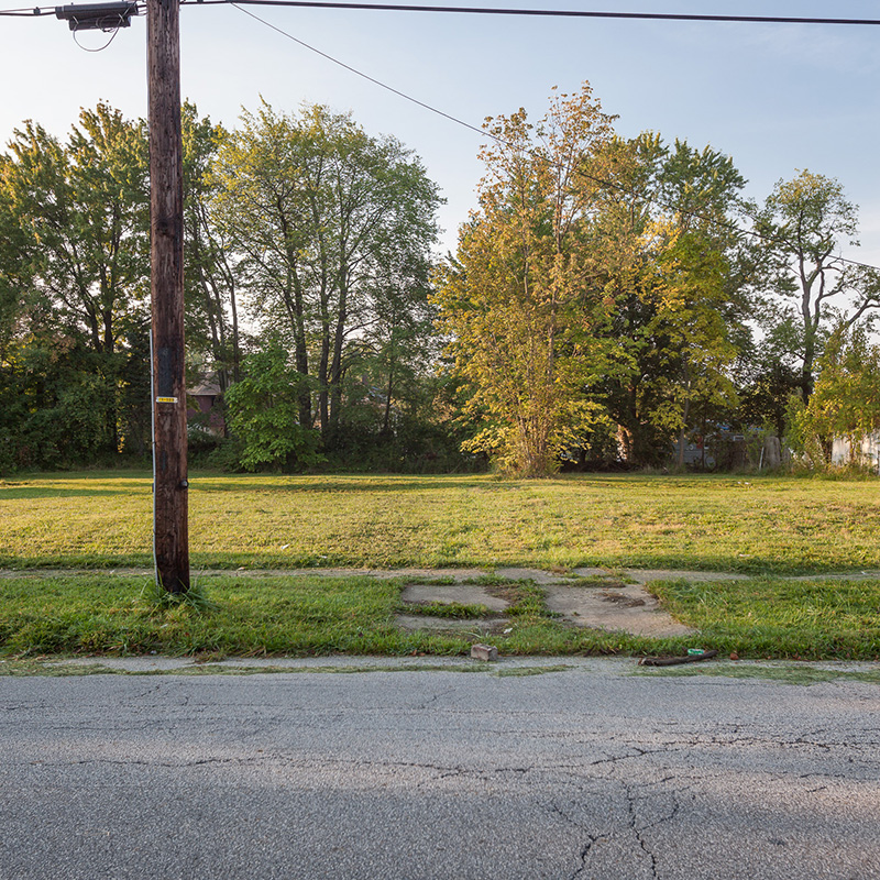
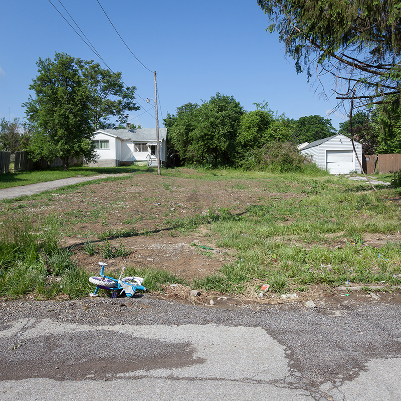
Most Americans will probably find it surprising to know that one in ten U.S. cities are currently experiencing stagnate or declining population growth. However, it should be no shock that the earliest urban deflation events are often attributed to the effects of deindustrialization and or globalization. Thus, it is fairly easy to understand why single industry manufacturing towns started taking it in the chin as early as the 1950s.  One town in particular that has suffered tremendously from the effects of deindustrialization is Youngstown, Ohio. Youngstown was named America’s fastest shrinking city as of the 2010 census. The city is located in Steel Valley between Cleveland, OH and Pittsburg, PA and once upon a time it was one of America’s great steel producing towns. Youngstown has suffered tremendously from its growth as an economic monoculture where steel dominated employment opportunities and most of the local economy. Between 1960 and 2010, Youngstown lost 60% of its population, deflating from a city of 170,000 residents to a town of 67,000. Not surprisingly, as of the 2010 census, Youngstown was recorded with the highest percentage of residents living in concentrated poverty and one of the highest violent crime rates in the nation. In 2006, the city reported the demolition of 2,566 structures. As of  2010, it was estimated that there are another 6,000 (GIS estimate) vacant buildings located within the 34 square miles of the city limits.

As early as 2002, the city of Youngstown began enacting a plan for cleanup and preservation that was later unveiled as the Youngstown 2010 Plan. The 2010 plan was a pioneering effort in "smart shrinkage", which was targeted investment to relocate people from areas of the city with high numbers of vacancies to more viable neighborhoods. The enacted plan would have created a spacious grid for an estimated 80,000 residents, however, the plan proved to be illusory. Since the unveiling of the plan in 2010, the city has lost another 15,000 residents; the poorest and most blighted parts of the city are still predominately black and the most prosperous and stable areas are still white; block watches and neighborhood groups are filling the gap left by an absentee local government; urban farms are popping up among the vast tracts of vacant land in the city and community and cultural groups are still struggling to make change happen. All provide evidence of a much larger breakdown in the governance and function of the municipality.  In his seminal 1992 book, about the former steel town of Homestead, Pennsylvania, William Serrin wrote, "America uses things; people, resources, cities and then discards them." Could it be that this statement sufficiently explains a larger reality for many small towns and cities around the globe like Youngstown, OH, that are experiencing urban shrink?  As the function, utility and quality of life is challenged in these places it is evident that we can no longer just abandon ship.

Stephen Chalmers earned his MFA in Cinema and Photography from Southern Illinois University. He was the NW Regional Chair for the Society for Photographic Education for two terms, a professor of Photography and Digital Media in the state of Washington for eight years and is currently a professor of Photography at Youngstown State University in Ohio. His series Youngstown, OH documents the “Urban Shrinkage” that has transpired in his hometown of Youngstown, OH.

You can find more from Stephen Chalmers here: http://www.askew-view.com

References:

  1. http://enviroliteracy.org/land-use/urbanization/
  2. Reference 2
  3. Reference 3
  4. http://www.huffingtonpost.com/the-groundtruth-project/how-youngstown-ohio-becam_b_5671919.html
  5. Tavernise, Sabrina (December 19, 2010). "Trying to Overcome the Stubborn Blight of Vacancies". The New York Times. Retrieved November 30, 2012.

FREE JOURNAL SUBSCRIPTION

Sign up with your email address to receive news and updates.

We respect your privacy.

Thank you!
_MG_0404.jpg
_MG_3363A.jpg
_MG_1777A.jpg
_MG_2467B.jpg
_MG_2998A.jpg
_MG_4021A.jpg
_MG_5967.jpg
_MG_7175AA.jpg
_MG_8876.jpg
_MG_9239C.jpg
_MG_0404.jpg _MG_3363A.jpg _MG_1777A.jpg _MG_2467B.jpg _MG_2998A.jpg _MG_4021A.jpg _MG_5967.jpg _MG_7175AA.jpg _MG_8876.jpg _MG_9239C.jpg

THIEU RIEMEN - Atmosphere in Agriculture

July 23, 2016

Images By: Thieu Riemen


Written by: Ryan Nemeth

Much of the Netherlands is a low marsh formed by the deltas of the Rhine and Maas rivers. A third of the country was at one point below sea level, it has since been reclaimed with dikes and drained through pumps run by windmills. In such a flat environment, the horizon seems to lie below one’s feet; thus, the sky overhead overwhelms the view.  A quality that inherently sets Dutch landscape painting and photography apart is the amount of space devoted to the sky. This has always been the case since the Dutch started painting Landscapes in the 1600s. The presence of the sky and horizon are further influenced by the intense and shifting light as a result of the country’s proximity to the sea. Thus, it is logical that Dutch landscapes often yield moody and atmospheric tones, strong horizon lines and overwhelming and piercing skies. You will see these qualities in Thieu Riemen’s work as he photographs the agricultural and rural lowlands of the Netherlands. I had the chance to talk with with Thieu about his work and here is what he had to say:

Ryan: Tell me about your upbringing in the Netherlands, were you raised near the places you photograph? What is your connection to the sites that you choose to photograph?

Thieu: I was raised in Tilburg in the south of the Netherlands, an industrial city in the heart of the province of Noord-Brabant. The prefix Noord (North) indicates that there must be a South and there is, in Belgium. In the past, North Brabant was part of the duchy of Brabant. Present-day North Brabant was adjudicated to the Dutch Republic according to the 1648 Peace of Westphalia, while the reduced duchy remained part of the Southern Netherlands until 1830, when it was incorporated into Belgium. I emphasize these facts to express the idea that the Dutch-speaking region where I live is one culturally coherent area. Furthermore, it speaks to my interest in the historical background of the places I photograph.

The Netherlands is a small country, so I was both raised and live near the places I photograph. For example, when I bike from Tilburg to the south, it takes a little bit more than a half-hour to reach the border of Belgium (10 miles).  Notably, the climate, natural scenery and language do not change in this short distance. However, things like architecture, land use and environmental planning are very much different. Thus, there are considerable amounts of cultural differences that transpire within a very small geographic area. It is worth mentioning that a significant number of my pictures are taken in Belgium, just on the other side of the border.  So ‘Dutch landscape’ as a subject of my photographic works should be considered in a broader sense.

The sites I choose to photograph are mainly rural and suburban places in the south of the Netherlands (the provinces Brabant, Zeeland and Limburg). Many of these places I have known since childhood and most are considered countryside. I feel that the rural orientation of my images allows me to see how we have changed and how we continue to change relative to our surroundings.  In the countryside, I feel the tension between nature and culture is at its best. For me, it is in these places that the signs and traces of human presence are juxtaposed in an interesting way relative to the natural world.  In a sense, non-natural and manmade objects seem a little more identifiable and recognizable relative to the rest of the landscape; they stand out. I say this also because the countryside is an environment where you can still see and feel the natural soil below your feet. However, in the Netherlands, all you have to do is look down for evidence of human intervention in the land as most of our farmland was reclaimed from the ocean.  

Ryan: I recently watched a documentary about the American photographer Gregory Crewdson. He often drives around in the same neighborhoods over and over until he sees or feels something that compels him to stop and make an image. I get the sense that you navigate through Dutch farmland in somewhat of a similar manner? How do you move about the land and what compels you to stop and make an image?

Thieu: I am familiar with Gregory Crewdson’s work, although my work is very different. I see a similar interest in the mystery of everyday subjects and in the sense of place, but my work is neither with narrative purpose, nor with elaborately devised settings. However, there are some parallels between the way we scout locations for our images. I tend to move around in certain areas over and over again with the changing light and through the different seasons. I am in search of the right setting and light that compels me to stop and make an image. I should mention that the way I move around is very important to me. Preferably, I like to travel by foot or by bike because it enables me to feel a deeper sense of connection with the landscape. This is a much different experience than watching the landscape unfold through a windshield. Also, for this reason, I use a 35mm format (digital) camera and a lightweight tripod, both are relatively easy to carry when walking. My lens of choice is a 24mm wide angle lens in order to convey the feeling of being in a landscape rather than looking at it.

Ryan: It is clear that you spend a lot of time investigating narrow geographies within the Dutch landscape. I believe that intense and focused investigation can lead to interesting observations and insights in relation to subject matter. What insights or knowledge have you learned while photographing the Dutch landscape?

Thieu: The Dutch landscape is a very small-scale landscape, it is densely populated, industrialized and crammed with all kind of built objects.  Therefore, it is literally filled with wonder as it is bustling with activity. What I observe in the Dutch landscape is a sense of endless transformation. For me, this brings to mind the popular saying “God created the earth, but the Dutch made the Netherlands”.

In answering your question, it is important to note that my photography is driven by an emotional involvement with places rather than by an attempt to gain some knowledge. Reflecting on this, it is and was never my goal to assert anything conclusive about the Dutch landscape. Thus, I don’t know whether my insights are that sensational or worth mentioning?  After so many years of photographing the Dutch landscape, the best I can say is that the Dutch landscape is a thing of tremendous beauty.

Ryan: Do you think that our interactions with agricultural land have changed? If so, where do you see evidence of this change?

Thieu: I cannot judge whether our interactions with - Dutch - agricultural land have changed very much. I am not a farmer, countryman or scientific researcher, but just someone who wanders around the countryside and someone who derives great pleasure in looking at the world through a camera.  However, I have noticed a growing attention to environmental issues and ecological aspects related to land use. Born from self-preservation (battle against water and pollution) but also from a renewed interest in nature in The Netherlands (new nature areas have been artificially formed).

You should bear in mind with regard to ecological aspects and other developments that some of them are visible, however a lot are not. I believe that the photographic image is only really capable of revealing the superficial or surface level of things. Thus, as a tool, the medium is somewhat limited in its capacity to comprehensively and accurately document environmental change. In photography, there is always the potential for some discrepancy between what we see and what is actually conveyed. Therefore, we often still need the aid of storytelling or language to elaborate on subjects and what is actually being viewed in images. So, I wonder whether a medium like photograph is an appropriate means for documenting or providing evidence of ecological change?

Ryan: One of the many qualities I notice in your work is your superb control of light. It is evident that you put a lot of energy and attention into controlling the intensity of light and tone of your images. Tell me more about your process for creating consistent exposures and soft image tones?

Thieu: My lighting decisions are all based on location as I believe that light and tone are captured in a singular unique moment in time. At home, my only goal in editing my images is to produce the light and colors that I saw on location or at least according to my recollection of it. In order to make this possible, I always shoot in raw mode to capture the physical information about the light intensity and the color of the scene. When the contrast in lighting is extreme, I take several images with different exposures. Subsequently in Photoshop, I can combine the relevant parts of the image.

Ryan: Ultimately, what motives or strategies lie behind your lighting choices?  What do you aim to communicate to viewers through subtle image tones?

Thieu: I prefer to take my photos with low light conditions, predominantly at sunset or at dusk. My choice for low or subdued light conditions has to do with my interest in the experience of a location. Many times at dusk, silence can descend on the landscape and at the end of a working day this contributes greatly to the atmosphere of a place. This helps define the experience of a location, I mean feeling the distinctive atmosphere or emotion that a location evokes; the ‘genius loci’, ‘spirit of the place’ or - as you like - ‘sense of place’. To me, the genius loci is a very meaningful aspect of those locations where I choose to wander around with my camera. Ultimately, the subdued colors and subtle tones inherent to low light conditions enhance the expression of an atmosphere of a place in my imagery.

Ryan: In scanning your work, it is evident that strong horizon lines are a prevalent part of your compositions. It is also apparent that you devote a lot of compositional space to the sky.  I am curious about your thoughts on both of these aspects found in your photographs?

Thieu: The Netherlands is extremely flat, there are some hilly areas in the Southeast corner of the country, but even in these regions you can see for miles around.  Dutch flat horizons have regularly little to offer, so the eye automatically wanders to the sky.  During my wanderings, my eyes often involuntarily linger at the sky. Out of mere fascination, but of course also in order to look for the development of light and weather for my photography. Thus, the combination of strong horizon lines and unbroken expansive skies are characteristic of the Dutch landscape.  Quite simply, I believe that these landscape features naturally train the eye to these focal points and therefore heavily influence my compositional choices.

A second and far more significant reason has to do with the mood of a place.  As I stated, the “genius loci” is a very meaningful component of landscape to me. The sky strengthens the expression of mood in a landscape while simultaneously conveying a feeling of transience and impermanence in all human enterprises. I am very interested in the history of a location or landscape; I read as much as I can about it and try to imagine how people before our times used and changed the landscape.  In my vision, the skies – although highly variable and changeable – are the timeless elements in the photographic image; they are never the same but substantially not changed since ancient times, thus eternal in contrast with volatile earthly things.

“The sky is the daily bread of the eyes” - Ralph Waldo Emerson

Ryan: I know that you are keen on documenting seasonal changes in landscape by repetitively photographing the same locations over and over, can you elaborate on this practice?

Thieu: I return frequently in different seasons when I feel a special bond with a place or when there is something in the setting that holds my attention. In this case, I am very interested in scenery that is transformed through development over time. I try to investigate this by photographing places in different seasonal circumstances and light. Usually, what I encounter is gradual change when revisiting a location over the course of many years, but sometimes there can be such startling change that a place is no longer of interest to me. For example, when a visually dominant building or impressive tree has disappeared.  At the same time, this revisiting of a place is simply an investigation to find out what makes a location unique, notable and interesting.

Ryan: It seems that many photographers produce work via a motivation to see, experience and construct something novel or new from their reality. Thus, experiencing something for the first time is one method for easily generating and documenting new experiences. One could easily assume that the act of photographing the same location over and over might challenge this concept. Do you feel that viewing the landscape in a repetitive fashion diminishes your capacity to document what you are seeing in a meaningful way?

Thieu: I believe that landscapes never become completely familiar; irrelevant of how often they are viewed.  The ever changing light and the moving seasons always seem to change the way we see certain locations. Even more, the changing light and seasons make us notice new aspects, details and points of view. Looking at the introduction of your question, it can also be argued that experiencing something for the first time could also have the risk to produce only superficial or obvious images?

Whether visiting new places or familiar ones, I think there is not very much difference in one’s motivation to take a photo. Such a motivation can arise only from experiencing something for the first time. In my opinion, we are compelled to take pictures when experiencing something new, no matter how small, nondescript or momentary this is. Consequently, I think that visiting and photographing the same place over and over again can be meaningful, if there is an aspect of experiencing something peculiar or undefined.

“Two or three hours walking will carry me to as strange a country as I expect ever to see. A single farmhouse that I had not seen before is sometimes as good as the dominions of the king of Dahomey.”- Henry David Thoreau from Walking.

Ryan: It is evident that your photographs largely speak to human interactions with agricultural and industrial landscapes. Why is it important to document the human experience relative to the agro-industrial complex?

My motivation to photograph human interactions within landscapes is driven an investigation to explore the way we have changed and how we continue to change relative to our surroundings.  In essence, I am driven to understand what motives people to act as they do and in the end by an even bigger question regarding the meaning of life. Our shared human experience relative to the agro-industrial complex is simply a part of this never-ending questioning.

On another - more banal - level, you can simply say that changes in the landscape are a result of our goal to provide food, housing and other needs for a growing population. I look at those changes with mixed feelings; they have an upside and downside. You can see some of my images as a record of these changes and I hope that some images will bring more awareness of what is happening to our world. Earlier in this interview, I shared my doubts about the photographic image as an unambiguous and straightforward message, but I certainly believe the photo can convey human (i.e. my) experience.

Finally, I would like to elaborate briefly on an - for me personally - important aspect of experiencing our surroundings. Beauty! The experience of beauty in (man-made) landscape and everyday subjects. Images reflect the surface of things and can be a source of aesthetic pleasure. When on location photographing, I have little problem being seduced by the enchanting surface of things or by the aesthetics of a place. A significant part of my photography is certainly driven by the lure or even by the pursuit of beauty. I believe the experience of beauty is an important component of the human experience and a meaningful thing in life.

“Beauty brings hope to the hopeless, gives worth to the worthless, gives sense to the senseless. It is not about truth, but it is a good thing… it is a comfort.” - Karl Ove Knausgård. (Norwegian writer,  loosely translated from Dutch)

FREE JOURNAL SUBSCRIPTION

Sign up with your email address to receive news and updates.

We respect your privacy.

Thank you!
View fullsize 1509_16_worked.jpg
View fullsize Octopus092.jpg
View fullsize 150312_Akutan_8656.jpg
View fullsize 150310_Akutan_6630_CA_v6_8x10.jpg
View fullsize 150311_Akutan_8196.jpg
View fullsize 140702_BristolBay_1105_R.jpg
View fullsize 140211_Aleutians_31355_2_max.jpg
View fullsize 150309_Akutan_5587-v2.jpg
View fullsize 150304_Akutan_0486-v3.jpg
View fullsize 140126_Aleutians_13324.jpg
View fullsize 140125_Aleutians_10747_R_3.jpg
View fullsize 100610_18_kodiak_0493.jpg
View fullsize 100324_Pollock_0228.jpg
View fullsize 140122_Aleutians_4939-Edit.jpg
View fullsize 140125_Aleutians_11212_CAv1.jpg

COREY ARNOLD - Talking Tides

July 23, 2016

Images By: Corey Arnold


Written by: Ryan Nemeth

Attracted by the opportunity to run a sawmill, my grandfather moved from Molalla, Oregon to the coastal town of Yachats (pronounced Ya-hots) sometime in the late 1950s. Yachats was and still is a sleepy little town of less than 1000 people in Lincoln County, Oregon. It is the kind of place in the winter where you can walk on the beach for miles and see no one. In fact, one is almost obliged to fall into introspection from the perpetual sound of crashing waves and the usual dense fog that engulfs the place.  At first glance, one could easily assume that the town has probably not changed much in fifty years.  Of course, there are new houses on the hill with bloated California prices, but the easy-going, laid-back vibe of Yachats still persists.  If one was inclined to try and figure this out, they might conclude that this is simply due to a lack of services; two or three decent restaurants, isolated beach front hotels, one small grocery store, a coffee shop, a bar, etc. Also, there is no navigable harbor in town; so there are no boat docks, no boardwalks and no ocean charters. But there is something more, or should I say less going on? Yachats is a place where the town’s connection with the sea prevails. Thus, the creature comforts associated with modern city life are nil and one is left to take in jaw dropping ocean views and seaside sounds unabated and without distraction from our modern existence.

What can I say? The place is good for contemplation and reflection.  While visiting two summers ago, I struck up a conversation with my father, aka “Billy Yachats”, about his recollections of town when he was young.  This sleepy little place etched lots of fond memories in my father’s mind, atop the list are line catching salmon in the Yachats River and hand hauling them in, digging for razor clams by the dozens and netting smelt.  Sure, people still land a fish or two at the mouth of the river, but the numbers of fish returning to spawn are pretty darn skinny these days; all that was is simply no longer. It is pretty astonishing to think that in just two short generations of my family, the biodiversity in this little microcosm of an environment on the Pacific Ocean has changed that much. This is even more shocking considering the fact that trade records of the Columbia River and Coastal tribes show that Native American trade networks were trading smelt oil “Ooligan” and salmon in quantity at the point of first contact. Furthermore, oral history and archaeological records push these dates back many centuries before prospectors and settlers arrived. Thus, it is fairly easy infer that human actions have played a significant role in interrupting the migratory flow and abundance of many coastal fisheries including those of Pacific salmon, smelt and bi-valves.

To elaborate, both salmon and smelt are currently listed as threatened under the Federal Endangered Species Act and razor clam harvests have largely migrated to Northern coastal beaches.  Back in the day, when my grandfather first moved to town, the fishing was bountiful and all three species were abundant and healthy.  So much so that in lean years and tough times, one could catch enough of all three to subside. As the matter of fact, the smelt used to run really hard around Yachats and fried smelt were a delicacy shared by my father and grandfather.  I have never eaten fried smelt, although I would love to and it saddens me to think that the Yachats I know today is very different from the town my father reminisces about. Although the place looks and feels the same to me, it is simply not the same experience without the fish running.  Most of us do not stop to think just how much biodiversity loss affects both the character and culture of place.

One does not have to travel to far North along the coast to find evidence of dramatic cultural change. Seventy miles North of Yachats on the Oregon Coast is the town of Pacific City.  Like Yachats, the town has no port, harbor or bay and ocean access is strictly limited to the beach. Pacific City is the home of the Pacific Coast dory boat and it is interesting for the fact that commercial fishermen have employed these unique boats to access the open ocean for more than 100 years. The dory boats are small flat-bottomed vessels and they are noteworthy because they can be launched directly from the beach into the ocean.  Pacific City also happens to be the only place on the West Coast where Dories are launched directly from the beach.  By the middle of the twentieth century, the Pacific City dory fleet numbered in the hundreds; this was largely driven by local demand from salmon canneries. Through the 1970s, there were as many as a dozen commercial Dory boat builders in Pacific City. Today, all but one seasoned boat builder remains; just like the fish, this amazing craft has all but dried up and the fate of the Dory fleet hangs in the balance.  

When my grandfather moved to the Yachats, fishing dominated conversations and local culture as this was simply a way of life up and down the Coast.  Irrelevant of one’s acknowledgement or willing participation, there was shared purpose and community in a coastal existence as life was intertwined with fishing and subsistence in the sea. Talk of the tides, the moon, the weather and what was biting is all that really mattered.  Over a pint or breakfast, one was always within earshot of a good fishing story or valuable advice from a seasoned fisherman. Although this culture still exists, it has largely been consolidated into a few small port towns like Newport, Or. What has changed dramatically is that the new owners of fishing folklore and culture have largely become corporations and industrial businesses as fleets have been scaled up and consolidated to deal with economic changes in the industry.

Once upon a time, ancillary industries like boat building and net and trap production were viable ways to make a living.  As evidenced in Pacific City, many of these operations are no longer as the demand and scale of the industry has shifted elsewhere. Resource scarcity, market volatility, and growing industry regulations have forced the industry to fish with bigger boats and to stay out longer in order to breakeven and produce profits. Much of this strategy precludes local fisherman and boat builders from even being involved; they cannot produce in the quantity required to make a living. Furthermore, there is always the looming risk of a bad season, price inflation or changes in demand, etc. It is these market pressures that have forced the consolidation of the industry and cajoled the fishing industry to morph into something entirely different.

In the end, what should be acknowledged is that both commercial fishing and coastal life around the globe have changed dramatically.  It is tough to even begin to make value statements on this topic for the fact that I support sustainable fishing and the culture that goes along with it. In many cases, we vilify the fisherman, failing to realize that what we do on land has a lot of consequence and impact for those that work at sea. Globally, we must begin to realize that our small human existence in tiny off grid places like Yachats matters and that what we do collectively as human beings impacts our larger global environment. Thus, the falling off of just one fish species and the degradation of biodiversity in local environments can have a dramatic global impact. My point is that this often shows up as change in local culture and economies resulting in a challenge to a life and existence that many know and love.  If you are at all inclined to believe that little sleepy off-beat places like Yachats, Or. are insulated from the world then think again! 

Corey Arnold is a photographer and commercial fisherman by trade. He has worked seasonally as a commercial fisherman in Alaska since 1995, including seven years of crabbing in the Bering Sea aboard the f/v Rollo. Corey now captains a commercial gillnetter, harvesting wild and sustainable Sockeye salmon in Bristol Bay, Alaska while living seasonally in an abandoned salmon cannery complex called Graveyard Point. His life’s work: Fish-Work is an ongoing photography series documenting the visceral experience of life at sea for commercial fishermen worldwide.

See Corey’s work here: http://www.coreyfishes.com

Current show and works for sale:  Charles Hartman Fine Art

References:

  1. McDowell, Robert M. (1998). Paxton, J.R. & Eschmeyer, W.N., ed. Encyclopedia of Fishes. San Diego: Academic Press. p. 116. ISBN 0-12-547665-5.
  2. Reference 2
  3. Reference 3

BRUCE PARKER - On The Beach Manzanita

July 23, 2016

ON THE BEACH MANZANITA: by Bruce Parker

It seems, as one becomes older, That the past has another pattern, and ceases to be a mere sequence — T. S. Eliot, “The Dry Salvages”


The smallest of waves sweeps the shallows and washes back

into oncomers — a white line forms, rips across

barely submerged sand, a lightning bolt of seawater.

The mind sweeps its memories back across incoming time

like a swirling pattern of unceasing sea, fractal yet fragmented,

touched and rearranged by embers of significance which glow,

sheet lightning in a thunderhead of the brain.


Seeing this ocean compound its movement,

on a walk with a lover, was sudden illumination, a glimpse

of understanding how the universe works, unsequenced,

developing nothing but moments, brief moments of happiness.


Love circles back to a wet embrace with an oncoming other,

shivers, slides swift and silent to light the memory

here and there in no order at all.

FREE JOURNAL SUBSCRIPTION

Sign up with your email address to receive news and updates.

We respect your privacy.

Thank you!
Braquenier5.jpg
Braquenier1.jpg
Braquenier2.jpg
Braquenier3.jpg
Braquenier4.jpg
Braquenier5.jpg Braquenier1.jpg Braquenier2.jpg Braquenier3.jpg Braquenier4.jpg

PHILLIPPE BRAQUENIER - Boundaries

July 23, 2016

Images By: Philipe Braquenier


Written By: Ryan Nemeth

Humans have long demonstrated the need for cultivating and maintaining barriers and boundaries within their habitable environments. At the most primal level, boundary and barrier creation serves as a human tool for enabling property ownership, security and the assignment of resources within defined geographies.  Digging deeper, recorded human history reveals that boundaries have always been leveraged as a basic unit of wealth and as a means for organizing and denoting power structures in society.  Thus, the human actions of gating and restricting access to both natural resources and human capital have long been repeated throughout history. This behavior has given rise to clans, tribes, and societies, while also fueling human actions of spatial demarcation and a need for the delineation of barriers and boundaries within our world.

In trying to understand human constructions of space, it should be noted that boundaries can be both real and imagined as well as imposed and exposed.  In simple form; boundaries manifest themselves as an extension of both the natural and unnatural world.  Natural and prominent borders are often formed via topographical and geographic features such as rivers, mountain ranges, forests, ravines, deserts and canyons.  Conversely, human constructed environments give rise to unnatural manmade barriers in the form of dams, reservoirs, lakes, roads and fences, etc.  History also demonstrates that humans have forever worked both with and against environmental resources to produce optimal and desired spatial configurations and efficient resource driven outcomes that preserve life.  In trying to make sense of boundaries and barriers, one must also acknowledge the role of human perception as humans influence the formation of real and perceived boundaries by way of psychology, culture, class divisions and sociological concerns.  In addition to the natural world, these human driven values and behaviors heavily impact the segmentation and division of human occupied space.  

As we move about the land and through built environments, it is interesting to consider how form, line, shape, light and the sensory congeal to form our spatial experiences. Dingy and dark spaces, disorder, jagged contours, decaying objects, traumatic memories associated with place and non-navigable environments are but a few elements that can make places and spaces feel inhospitable. On the flipside, smooth and rounded edges, beautiful colors, bright light, order, symmetry, and clean spaces are just some of the triggers that contribute to favorable environmental affect and positive interactions with our world. It is interesting to ponder how natural and constructed environmental triggers shape the sensory and or our perception of space.  Ultimately, these considerations dictate where we choose to go, what we avoid, how we live and what we do and feel as we move through our experiences of space and time.  I do not know about for you, but for me, the thought of identifying, confronting, and challenging environmental and self-imposed barriers and boundaries seems like an invitation and an opportunity to live with less restrictions and more freedom in life, challenge accepted!  

FREE JOURNAL SUBSCRIPTION

Sign up with your email address to receive news and updates.

We respect your privacy.

Thank you!

HARVEY WANG: Remembering Adam Purple

July 23, 2016


THE GARDEN OF EDEN - An original work of art by Adam Purple

Photography by: Harvey Wang / Written By: Amy Brost  


An excerpt from: Adam Purple and the Garden of Eden, published by Traveling Light Books.

January 8, 2011, marked the 25th anniversary of the destruction of The Garden Of Eden, an earthwork that once spanned five city lots on Manhattan’s Lower East Side. The fact that it is no longer extant could account for its absence from land and environmental art scholarship, along with the fact that the artist, Adam Purple (David Wilkie), lived within the city but in many ways totally apart from it. His desire to use his earthwork as a way to confront both the surrounding urban environment and the attitudes of its inhabitants eclipsed any desire he had for recognition by the art-world establishment. A search of the literature yields no substantial discussion of Adam Purple’s role as an artist, nor is he mentioned in discussions of contemporary “environmental” artists working with related themes and approaches. What one does find is a significant number of articles in the news media in the 1980s covering the controversy surrounding the destruction of The Garden of Eden. While this part of The Garden’ s existence is well documented, there has been no survey of Adam’s work, including his anti-establishment leaflets and hand-made books that recognize Adam as an important artist in his own right. Adam had no formal art training, though he did apply for and twice receive Artist Certification from the New York City Department of Cultural Affairs. He considered himself an “environmental sculptor” and called The Garden his “Earthwork.” Still, he never devoted time to developing a “career” as an artist and had no art-world protégés. As such, he was not an influential part of a movement per se, but he was nonetheless an important American environmental/ecological artist. Particularly noteworthy is that, over the course of more than 10 years, Adam Purple executed a fairly large-scale earthwork in the heart of one of America’s largest cities, without financial patronage and with little more than his own two hands and a bicycle.

David began The Garden Of Eden behind his tenement building at 184 Forsyth Street. Soon thereafter, he developed his artist persona and began using the pseudonym Adam Purple. The site was located in Block 421 of Eldridge Street between Stanton and Rivington Streets, in the heart of Manhattan’s Lower East Side, occupying lots 63, 64, 65, 67, and 68.  In a 2006 interview for the Story Corps Oral History Project, Adam was asked why he chose this site for his endeavor, and he replied:

         “So, when I looked out my window...before the buildings on Eldridge Street were taken down, I was watching mothers sitting in the back  window of a tenement building looking at their children playing in the garbage in the basement pit behind the building and I thought, wow, that’s a hell of a way to raise children, with no place to, you know, put your feet on the dirt.”

When Adam began working on the site in 1975, much of Manhattan’s Lower East Side had become a dangerous, violent, drug-ridden wasteland. In the midst of this, Adam began the process of clearing 5,000 cubic feet of debris from the two lots behind his tenement building. Adam was determined to create The Garden Of Eden by hand, without the use of engine-powered tools of any kind, not even vehicles. He argued that the automobile, along with what he called the “infernal combustion engine,” were “counterrevolutionary,” whereas The Garden would represent environmentally sound reclamation of abused land. The bulldozed, un-sifted compacted rubble was 12 to 18 inches deep, and covered each lot. Adam estimated that a 6-story, 24-apartment building would have approximately 300,000 whole bricks, many of which would be broken or pulverized during demolition. Adam dug into the debris with a pick and manually sorted out the materials in the rubble. He kept whole bricks to use for pathways in The Garden, but the broken bricks (“bats”) he considered unusable, except for use in “brick-bat calligraphy.” On the whole, he found that two-thirds of the rubble was unusable, and broken glass, plastic, etc., were discarded. However, some of the unusable material was still recyclable; the surplus whole bricks could be sold for about 25 cents each, and pieces of iron, copper, and lead could also be recycled. Wood could be burned and the resulting ash used in soil production. He twice sifted the finer debris, first with a half-inch screen, and then again with a quarter-inch screen, to separate the small gravel that could be used for walkways from the sand that could be used in soil production.

In addition to brick sand and potash from unpainted burned wood, Adam needed one more essential ingredient in his recipe for virgin topsoil – manure. To haul this material, Adam lashed a milk crate to the rear rack of his purple bicycle with polyester rope. Almost daily, he made the seven mile round trip to Central Park to bring carriage-horse manure back to The Garden. He was able to carry about 60 pounds on each trip.  Wearing purple tie-dye and collecting horse manure tended to draw a fair amount of attention, and Adam called this activity an act of “conspicuous conservation.”  Adam termed his combination of potash, brick sand, and horse manure the “maxi-method” of topsoil creation, and claimed that it would generate 2,167 square feet of topsoil per person per year.  His corresponding “mini-method” of soil creation added square feet per person per year of topsoil, and involved composting his own vegetarian human feces, kitchen vegetable peelings, and dead leaves from nearby Sara Roosevelt Park, along with other weed prunings.

After starting The Garden Of Eden, Adam saw and admired the circular garden designs in Garden Cities of Tomorrow by Ebenezer Howard, a 19th-century utopian city planner. In Howard’s diagrams, each garden city unit was comprised of concentric circles radiating out from a civic center. These circles contained ample parkland, residences, and shops, with small factories on the outermost edge. The area between garden cities was all country and farmland. One of Howard’s plans included the prominent caption, “Illustrating correct principle of a city’s growth – open country ever near at hand….” Each of the circular plant beds took Adam an average of five weeks to make. He made the borders out of salvaged bricks reinforced on the inside edge by salvaged sheets of galvanized sheet metal.  The pathways were made from the bricks that Adam chose for their superior beauty and he organized them into labyrinthine walkways and filled the gaps with sand.

In following years, more tenements were torn down and Adam expanded The Garden Of Eden to occupy five lots by 1982.  The Garden grew to 15,000 square feet of flowers, herbs, trees, fruits, and vegetables, as well as 100 rose bushes and 45 fruit and nut trees. Adam’s crops included sweet corn that grew taller than he was, all manner of fruits (strawberries, apples, pears, apricots, nectarines), vegetables (asparagus, cucumbers, leaf lettuce, string beans, green peas), and the city’s largest public black raspberry patch, grown on salvaged mattress springs on a Connecticut dry stonewall. Garden snakes, brown thrushes, toads, walking sticks, butterflies, bees, and praying mantis all made their way to The Garden. Plantings included eight black walnut trees, a myriad of flowers, sweet (white) alyssum and ornamental (purple) basil to create the double yin-yang symbol, and one Chinese Empress (Paulownia) tree near its center. 

Adam submitted a detailed description in his “Rubble Reclamation” article published in the Horticultural Society of New York’s Garden magazine, July-August 1979. The Editor wrote of Adam and his then-partner Eve: “With little or no help from the outside world, they have transformed a large vacant lot in one of the most foreboding areas of the lower East Side into one of the most imaginative and productive ornamental gardens in the City. […] What they lack in money they make up for by ingenuity, hard work and devotion.”

BUY THE BOOK: AMAZON

FREE JOURNAL SUBSCRIPTION

Sign up with your email address to receive news and updates.

We respect your privacy.

Thank you!
Untitled-(Southern-California),-2013-(3).jpg Untitled-(Oakland-CA),-2014-(2).jpg Untitled-(Meteor-City-Arizona),-2013-(2).jpg Untitled-(Southern-California),-2013-(2).jpg Untitled-(Joshua-Tree-CA),-2014.jpg Untitled-(Southern-California),-2013.jpg Untitled-(Meteor-City-AZ),-2013.jpg Untitled-(Meteor-City-Arizona),-2013.jpg(3).jpg

JUSTIN CLIFFORD RHODY - Land of Enchantment

July 23, 2016

Images By: Justin Clifford Rhody


Written By: Ryan Nemeth

Humans have long expressed favorable sentiment for the open road and I must confess that some of the most liberating moments in my life have been experienced while rocketing down the blacktop.  Longing for new experience, I packed my bags and moved West from Austin, TX. in 2000. The drive to Santa Fe, NM yielded endless horizons, new colors and piercing light in shades of sky that I did not know existed. I suspect that many traveling the Old Santa Fe Railroad must have had very similar experiences as their train sliced through the desert landscape into a new and foreign reality.  

Northern New Mexico is noted for its remarkably intense skies; thus, flatlanders like myself are often left dumbfounded and fumbling through words to describe the sculptural qualities of the land and the pastel colors that ooze up from the earth.  As one progresses into the elevation of the high desert, tree lines become minimal and elevated vantage points usher in scenery that is inherently dominated by a persistent sky. The seemingly limitless skyscapes display a kaleidoscope of rich indigo blues during the day and an intricate web of sharp white stars that pulse through the night.  

Much like the experience I had when first standing on the rim of the Grand Canyon, I could look up to the Northern New Mexico night skies and comprehend the scale of my meager human existence.  For more than a century now, artists and writers have traveled to the region to download and interpret the cultural landscape and skyward eccentricities that unfold in this oasis of land and light.  Nicolai Fechin, Georgia O’Keefe, Alfred Stieglitz, Ansel Adams, and D.H. Lawrence are among a few that have been touched by the magic of Northern New Mexico and I suspect that this inspiration will continue on in perpetuity.

Maybe it is the persistent and inescapable invitation to commune with the sky that makes the solitude of the high desert so transformative and enigmatic.  In fact, evidence in the form of ruins suggests that the heavens of Northern New Mexico have always secured a captive audience.  Archaeoastronomy was a hallmark of the Pre-Columbian Chaco Culture that inhabited and dominated the area. Thus, Chacoans and the Anasazi cultures aligned their buildings with the sun and stars such that their rhythm and pace of life was in line with the seasons. Although Chaco Canyon was abandoned around 1250 A.D., this imprint of ancient culture remains an accessible portal to our past and a relic of skyward inspiration that has persisted in the Southwestern desert for eons.  For those that are looking to experience the magic of Northern New Mexico, I would tell them to start their experience by simply looking up!

References:

  1. http://www.nps.gov/chcu/index.htm
  2. http://colony-t.nm-unlimited.net/

FREE JOURNAL SUBSCRIPTION

Sign up with your email address to receive news and updates.

We respect your privacy.

Thank you!
7.Encounter.21.0006.jpg
10.1500.Draped-Electric-Wire.5180.jpg
2.Encounter.24.jpg
3.8457.jpg
9.AB.0754.jpg
5.Encounter.9.0717.jpg
8.1500.Wasteland-Ecology.0004.jpg
6.Encounter.2487.jpg
11.Encounter.43.5220.jpg
14.Encounter.2286.jpg
12.Field-Note.9599.jpg
15.Encounter.48.0834.jpg
7.Encounter.21.0006.jpg 10.1500.Draped-Electric-Wire.5180.jpg 2.Encounter.24.jpg 3.8457.jpg 9.AB.0754.jpg 5.Encounter.9.0717.jpg 8.1500.Wasteland-Ecology.0004.jpg 6.Encounter.2487.jpg 11.Encounter.43.5220.jpg 14.Encounter.2286.jpg 12.Field-Note.9599.jpg 15.Encounter.48.0834.jpg

EDGELAND SPACE: Jennifer Colten

January 16, 2016

Images by: Jennifer Colten


Written by: Ryan Nemeth

Many of us assume that the spaces within our city’s boundaries naturally fit together like pieces of a puzzle. Thus, it is easy for us to assume that all of the lands within the defined boundaries of our cities have been assigned productive functions. This is especially true when we think of urban environments in context to a grid system and highly developed city-zoning ordinances. However, having neat and orderly areas within our urban centers does not necessarily mean that cities behave in a predictable fashion. In fact, something both unremarkable and unruly often exists when land use ordinances collide within the urban core. Overlapping land designations and competing functional interests often create dead zones or tracts of land with confused and unassigned values. Yet, these indifferent spaces are inevitably much more complicated than this simple assessment. The reality is that our cities have many inactive patches of land that fall out of favor with humans for many reasons.

The English writer Marion Shoard took note of these complex environments and coined the term “edgelands” to describe these often overlooked and discarded spaces.  Thus, edgelands are loosely defined as places that occupy spaces both in between and on the periphery of inhabited and functional space. So, I am sure you are wondering in between what? Yet, the paradox of trying to assign a proper definition to the edgelands is that these spaces are transitory and therefore often tough to pin down and define. The edgelands are commonly found where the urban and rural collide, however, these spaces also exist around the periphery of parking lots, industrial sites, business parks, airports, waterfronts, suburban neighborhoods and alongside transportation corridors such as highways, rail lines and parkways. Due to urban migration, huge numbers of people now spend much of their time living, working, and or moving within or through edgeland space. Yet for most of us, this mysterious and unremarkable no man’s land often passes unnoticed in our daily commute.

Photographer Jennifer Colten has spent a lot of time contemplating and documenting edgeland space. It is worth mentioning that the edgelands are an interesting place to point a camera as they are distinctively non-photogenic commonplace spaces.  However, Colten’s work reveals that there is something interesting happening in these humdrum urban corridors.  Her images reveal that there is in fact a unique and complex dialogue between nature and the built environment that exists in edgeland space. I had a chance to catch up with Jennifer Colten on concepts surrounding edgeland space and here is what she had to say:

1. How would do you define edgeland space and what is your fascination with documenting this space via the photographic medium?

Edgeland spaces are spaces that occupy a certain ambiguity. They are spaces that were not built for particular purpose nor used in easily identifiable ways. They are generally places at the periphery, or in between other more definable areas. Therefore we are not generally aware of them. The transience or flux of these kinds of places is interesting to me. In some ways, I see the photographic medium as perfect vehicle for exploring this kind of space. The spaces themselves are elusive and fleeting and photography, especially digital photography, is suggestive of this immateriality or fluidity of information.

2. Is edgeland space a place? Clearly edgeland spaces exist as we can find these locations through GPS coordinates; or for example, you could tell someone how to find a prior site you photographed. But does the human psyche treat these spaces differently, or in a manner that might challenge traditional concepts of place?

I think that in order for a site or a space to be defined as a “place” entails a sort of engagement with the space; a relationship that is produced through experiences, or memories, or even desires. This is why I title some of the images with the word “Encounter”. It implies a negotiation or relationship with the site. At one point, I was very interested in the idea of locating “place” and defining how or if that could be identified? Now, I am less interested in pinning down a definition of “place” because I see this as a shifting condition. This relates to the inherent qualities of ‘edgeland” spaces.

3. Do you find it challenging to draw beauty out of these environments or is this even your intent in photographing these spaces?

Beauty is a complicated word and such a big idea. I am not setting out to “beautify” these spaces, however, I do see a certain poignant aspect to these places. In an attempt to see a place that is filled with a complex and maybe paradoxical set of circumstances (from its quiet details, to an unsettling acknowledgement of its decay), I suppose there is a particular kind of beauty. I am definitely not interested in glamorizing places that have undergone destruction, social, or economic hardship. Nor am I interested in glamorizing the degradation of our environment. But, there can be elegance in seeing complexity and contradiction.

4. The photographic medium always produces output that is some part objective and subjective. With this in mind, do you approach the documentation of edgeland space with a more objective or subjective intent? Do you wanting viewers of your work to see these spaces for what they are, or something different, or maybe a combination of both perspectives?

One of the things that I love about photography is that it can be a continual paradox. On the one hand it can appear to present direct information. It can appear to be objective. However, photographs are never objective. They are always an interpretation, sometimes a fiction, and sometimes a complete fabrication. For me, it is the interesting line right in the middle that is compelling. When a photograph simultaneously, provides descriptive qualities that alludes to objective information, and also provides open space for interpretation and suggestion, it is most intriguing! So, I do want viewers to see the spaces both for what they are AND I want them to come away with questions, with discomfort, and with a powerful sense of poetic interpretation.

5. The English poets Farley and Symmons Roberts claim that the edgelands are interesting spaces because they cannot be pinned down. Do you think that these areas of our landscape remain fluid and dynamic or are they inherently more static and idle in nature, why?

I see edgeland spaces as fluid and ever-changing spaces. They might appear to be static, because often they are not obviously occupied and they are not clearly marked by traditional boundaries. It is this fluidity that I am particularly interested in. I often return to sites over and over, not only to remake photographs, but also to see the landscape as it changes with time and with weather and with season. I am interested in how the landscape shifts in response to both natural and man-made events. That nature and the literal shape of the land have a certain power and resilient capacity is strangely comforting. The concept that nature will evolve and change, often in spite of our interventions is a powerful fact.

I sometimes hesitate to put this idea out there because it is complicated. I firmly believe we humans have a deep responsibility to take care of the environment and to be held accountable for our activities; the environment has surely been affected by our irresponsible or oblivious decisions. However, that nature will survive and evolve in spite of us humans is hopeful.

6. Can the periphery, the margins, or edgeland spaces exist as productive areas of land, or do you think that these areas of land must exist in only a transitory or idle condition?

I frequently drive by a particular place that makes me think about this very question. Are there productive uses for those spaces that exist by happenstance? What about the spaces that are left over when the road is built and there is that awkward zone in-between the highway and the overpass? The spot I mention, is a very narrow strip of land that has been turned into an urban garden. This garden is extremely lush and productive and exists on a patch of land that was previously a dead zone. At one point, this garden was an edgeland space right in the middle of the city. Yet, for a time it was totally overlooked, a leftover piece of land that seemed to have been an afterthought. The proactive choice to use this space for a productive vegetable garden is beautiful!

The shifting aspect of edgeland space makes its very definition one that stays open ended and somewhat undefined. So, as this beautiful urban garden is now a place; meaning it has activity, it has purpose, it has usage and we are aware of it as a marked space, I suppose it loses its edgeland definition. It is the ever-changing transitory nature, or the seemingly idle condition that defines an edgeland space. But, we see that edgeland space can evolve into a productive space, and certainly productive places can transition into edgeland spaces.

7. Are edgelands a mere product of the growth of modern urban environments or do you think that they exist as some manifestation of the unknown, unexplored, or unfamiliar? Thus, do you think a concept similar to edgeland space existed for the 18th century farmer?

I think there is something closely related to the idea of the unknown or unfamiliar or unexplored. The edgelands to me are intriguing kinds of spaces because of their relationship to uncharted territory. It is the paradoxical relationship between the familiar kinds of places and familiar objects coupled with all the things that have been left behind that creates a tension.. The specific clues that reveal activity that once occupied the space, in contrast to the open ended and undefined aspect of these places creates a tension. What we think we know of a place is simultaneously unknowable.

8. What do you think about the idea of edgeland space existing as a wildlife corridor? Evidence suggests that there can be a lot of biodiversity in unmanaged spaces like edgeland areas. Do you think that edgeland spaces can exist as a place of refuge for flora/fauna and wildlife?

In my ongoing project, Wasteland Ecology, I am specifically looking at the ways the land shifts and reshapes itself around old industrial sites and old toxic waste zones. The ways that vegetation and even the shape of the land have been affected by human activity is profound. I have no training in plant biology or wildlife ecology, but it is clear to me that the landscape is altered. I have to imagine that the plant life is completely changed by human interventions. Thus, it is interesting to imagine that new species might evolve as a result of these alterations and that the unnoticed and unmanaged edgeland sites might be places where new growth can thrive. This concept speaks to the heart of my strangely hopeful outlook about nature’s resiliency. It just might be that these edgeland sites that are sometimes byproducts of our human industrial society provide the kinds of places where new vegetation and life can emerge.

Thanks for taking the time, this has been an enlightening conversation! You can find more of Jennifer Colten’s thought provoking work here: http://www.jennifercolten.com

References:

  1. https://en.wikipedia.org/wiki/Edge_city
  2. https://courses.planetizen.com/course/urban-design-edges
  3. https://gerryco23.wordpress.com/2014/02/09/wildness-on-the-edge-of-town-an-edgelands-encounter-with-paul-farley-and-michael-symmons-roberts/
  4. http://www.marionshoard.co.uk/Documents/Articles/Environment/Edgelands-Remaking-the-Landscape.pdf

FREE JOURNAL SUBSCRIPTION

FREE BI-ANNUAL ISSUES of TERRATORY JOURNAL - Sign up with your e-mail address.

We respect your privacy.

Thank you!
Sandmotor-01.jpg
Sandmotor-03.jpg
Sandmotor-05.jpg
Sandmotor-02.jpg
Sandmotor-04.jpg
Sandmotor-01.jpg
Sandmotor-06.jpg
Sandmotor-04.jpg
Sandmotor-01.jpg Sandmotor-03.jpg Sandmotor-05.jpg Sandmotor-02.jpg Sandmotor-04.jpg Sandmotor-01.jpg Sandmotor-06.jpg Sandmotor-04.jpg

LAND THIEVES: A war on rising tides

January 16, 2016

Images by:  Bart Van damme


Written by: Ryan Nemeth

The Dutch Sea Beggars were a sordid lot of sailors comprised of adventurers, pirates, and patriots who were fighting against Spanish rule in the Dutch provinces during the mid to late 1500s.  These pirates and privateers acting on behalf of their lowland nation found a good bit of success stealing the Spanish Empire’s wealth at sea. History tells us that the Sea Beggar’s efforts were the precursor to Dutch independence from Spain as well as several centuries of Dutch global maritime dominance. The other development that contributed greatly to Dutch prosperity during this period was success in transforming their agriculture through hydraulic engineering. Did you know that approximately one-quarter of the Netherlands lies below sea level? Therefore, it is both striking and a sign of human ingenuity that the Dutch continue to create competitive advantages for their country via their unique land management efforts and a deep and sordid history with the sea.  The Sand Motor project, is yet another pioneering land transformation endeavor that is enabling the Dutch to safeguard their land from depths of the ocean.  

Hold your horses people, we will get into the details of the Sand Motor. Let’s first explore the history and evolution of Dutch land reclamation efforts through windmills, dykes, and polders. As Doug E. Fresh would say, Tic Toc and you don’t stop and it goes a little something like this, hit it... In the first century A.D. people began building artificial hills, called terps, and locating their villages and towns on top of them so that when floods came their homes would be safe. After a while it occurred to these people that if they connected the terps together with long walls, called dikes, they could keep water out of their farmland. Thus, the Dutch built dikes around water saturated areas of their land. The next stage of evolution in land transformation involved pumping water out of the lowlands.  In order to do so, pumps were connected to wind powered mills, enter the windmill in the Dutch landscape.  Successful efforts to expand this network of dikes and the use of windmills furthered land reclamation capabilities and capacities.  Many centuries later, the end result and application of this ingenuity enabled the Dutch to transform bays, flood zones, marshes, and lakes into arable and inhabitable land.  These recovered areas of land surrounded by dikes were given the name polder. Thus, dikes, windmills, and the creation of polders are features of the Dutch landscape that are inextricably linked to one another. If you were wondering how on earth you reclaim land from the sea, this folks is exactly how you do it!

Hopefully it is evident by way of the abbreviated history presented that the Dutch are engaged in what seems like an endless battle to preserve their land from the depths of the ocean. Although windmills are now picturesque and cliché symbols of Dutch culture, they are also objects tethered to a long history of environmental struggle. This struggle, the coinciding efforts, and a relentless obligation to contain nature have persisted from father to son for centuries. Thus, environmental awareness is a huge part of Dutch cultural identity. Many would argue that this level of awareness was birthed out of a deep and sordid history with flood control and intense land transformation efforts. The popular proverb, “God created the Earth, but the Dutch made Holland,” says it all.  However, this is more than proverbial truth, as it speaks to a very tangible cultural reality in the Netherlands, the Dutch are co-creators in their functional landscape.

Like any good story, the saga continues, enter the “Sand Motor” in the Dutch landscape. Although the branded “Sand Motor” project begs for a literal interpretation, it is hardly that.  I have to admit that this name immediately conjured up scenes from Mad Max. I was hoping to discover the biggest and baddest machine on earth in action. Clearly, we all need a 2000 horsepower machine that can sling many tons of sand hundreds of meters in 10 seconds flat. All I have to say is that it was a good pipe dream while it lasted! However, the Dutch are way smarter than this. They happen to have a long history of working with the forces of natural energy (kinetic) to aid their landscaping and earth moving efforts. Windmills and the coinciding hydraulic energy they produce are a prime example of this applied intellect.  In the case of the Sand Motor project, the Dutch are using the ocean’s currents as a means for building up their beach. So you ask why? This project is a direct response to projected sea level rise and a derivative of this coastline intervention method that has helped the Netherlands combat coastal erosion since the 1970s.  It you are wondering what we might do to combat rising seas in the near future?  Read on, the solution might be in front of our face, thanks to the Dutch!

The global science community largely agrees that climate change and rising sea levels will pose a significant threat to deltaic, estuarine, and other low-lying coastal regions in the 21st century.  The damage done by hurricane Katrina in 2005 was a global wake-up call to many countries concerned about the potential consequences of coastal flooding. In fact, this incident galvanized the need for a 2nd Delta Committee in the Netherlands. The Netherland’s is largely comprised of river delta and is therefore faced with potentially massive socio-economic consequences in the event of flooding related to sea level rise. More than half of the Dutch population (9 million people) currently reside in coastal regions, with nearly 65 percent of the Dutch Gross National Product being produced in these coastal regions. Thus, there is a considerable amount at stake for their country and our global community in coming decades.

The “Sand Motor" aka the “Sand Engine”, is a sand nourishment project comprised of 21 million cubic meters of sand. This is roughly 67,000,000,000 trillion pounds of sand, literally, a shit ton of sand!  But what is it you ask? The “Sand Motor” is a man-made hook shaped sand bar that stretches out from the natural beach to form a peninsula in the ocean. Between March 2011 and November 2011, Rijkswaterstaat and the provincial authority of Zuid-Holland broke ground on the 70 million euro sand-spreading project. Globally, the project is notable because its magnitude and scale are unprecedented.  As mentioned, the Dutch have been building sand bars on a smaller scale to combat sea level rise since the 1970s. So what is the difference compared to prior sand replenishment efforts and why such change?

Historically, the Dutch applied sand directly to their dunes and receding beaches. Learning from this process, beginning in the 90s, the Dutch began utilizing shore facing or shorefront sand nourishment methods. This method utilized natural marine processes to redistribute sand placed under water in a cross-shore direction. This gradually created a wider beach and increased coastal defenses over time. The difference is that the Sand Motor is considered a mega-nourishment of sand and it exploits both the energy from water currents as well as wind to redistribute sand in both cross and along shore directions. Thus, the hope is that there will be more sand spreading coverage that utilizes energy from both natural sources (wind and waves).

It is interesting to consider some history here. In the 1990s, Dutch sand replenishment activities were usually on the scale of 1-2 million cubic meters. This was the total sand applied annually and these efforts were usually effective enough to provide 3-5 years of coastline protection. The sad truth is that the size and magnitude of these replenishment efforts have grown simply from current climate modeling data. In 2009, the aforementioned 2nd Delta Committee indicated that to negate the enhanced potential for coastal recession, due accelerated sea level rise in the 21 century, the yearly sand nourishment volume for the Dutch coast should be increased from a total volume of 12 million cubic meters to 80 million cubic meters a year. This proposal is ultimately what led to the methodology change and the concept of the “Sand Motor”.

The justification and main advantages of the Sand Engine concept are: (a) sand replenishment is only required approximately every 20 years as opposed to the 2-5 year cycle of prior methods; (b) the sand replenishment will slowly diffuse and advance the shoreline over a 10 km stretch of the coastline and in a more natural fashion; (c) the large initial local ecological disturbance will result in a short to medium term increase of locally available space for recreation and the environment, and (d) the ecological stress, while considerable at the initial nourishment location, does not disturb adjacent areas, thereby limiting the disruption to a small 2.5 km area. Currently, the project and local area are being researched extensively and evaluated via multidisciplinary research methods. While the jury is still out on this unique intervention, if proven successful, it may well become a global generic solution for combating sea level rise driven coastal recession on open coastlines.

P.S. If you live in Hawaii, Tahiti or any the Pacific Islands, I am sending this message to you, maybe there is hope after all!

References:

  1. Stive, M., De Schipper, M., Luijendijk, A., Ranasinghe, R., Van Thiel de Vries, J., Aarninkhof, S., Van Gelder-Maas, C., De Vries, S., Henriquez, M., Marx, S. (2013). The sand engine, a solution for vulnerable deltas in the 21st century. Coastal Dynamics 2013. Retrieved from: http://www.coastaldynamics2013.fr/pdf_files/148_Stive_marcel.pdf.
  2. Bruyneeel, M. (No date) The Dutch Sea Beggars. http://zeerovery.nl/history/beggars.htm
  3. Krystek, L. (2011). The Zuiderzee and Delta Works of the Netherlands. Retrieved from: http://www.unmuseum.org/7wonders/zunderzee.htm.
  4. Maddison, A. (2015). The Netherlands from 1600 to the 1820s. Retrieved from: http://www.theworldeconomy.org/impact/The_Netherlands_from_1600_to_the_1820s.html
  5. McKinney, V. (2007). Sea level rise and the future of the Netherlands. Retrieved from: http://www1.american.edu/ted/ice/dutch-sea.ht  

FREE JOURNAL SUBSCRIPTION

FREE BI-ANNUAL ISSUES of TERRATORY JOURNAL - Sign up with your e-mail address.

We respect your privacy.

Thank you!
01-DSC_2868-t.jpg
01-DSC_2871-t.jpg
01-DSC_2876-t.jpg
01-DSC_2898-t.jpg
01-DSC_2948-t.jpg
01-DSC_2903-t.jpg
01-DSC_2923-t.jpg
01-DSC_2925-t.jpg
01-DSC_2977-t.jpg
01-DSC_2967-t.jpg
01-DSC_2929-t.jpg
01-DSC_2953-t.jpg
01-DSC_2940-t.jpg
01-DSC_2980-t.jpg
01-DSC_2946-t.jpg
01-DSC_2954-t.jpg
01-DSC_2971-t.jpg
01-DSC_2984-t.jpg

RUINS: Post-Industrial Society

January 16, 2016

Images by: Markus Lehr - From the series: Modern Ruins


Written By: Ryan Nemeth

Factories and industrial sites are more than just standardized homogenous places where we produce things. During the industrial revolution, industrial zones and production centers also served as community outlets and incubators for innovation. Our factories and assembly lines were the places where we produced value for society and challenged mediocrity. In doing so, scaled manufacturing became the 20th century model and mechanism for ushering in wealth and culture to the Western World. Thus, industrial centers also became the rallying points for generating the competitive advantages needed for our economic growth.  Under this industrial economic model, societal benefits were numerous and we had both rationale and incentive to build and maintain the “factory town”.  

As a result, the factory floor was a place that provided for generations of our families. For the better part of a century, the assembly line enabled upward social mobility in the Western World. The production plant was our method for building and enabling a middle class that afforded homes, cars, healthcare, college, and retirement. Yet, the promise of increased profitability (capitalism) quickly challenged what was good and well, enter the service economy.  As industries created wealth and leisure, we demanded more and our service sectors grew fast to keep pace. We began demanding higher quality, at lower prices, with more variety and the bottom line prompted businesses to continue outsourcing their manufacturing jobs.  Fast forward fifty years and what remains of a once vibrant Western production empire is a scarred landscape filled with factory ruins that serve as portals to a vibrant industrial past.

Sizable changes in service sector composition were first documented by U.S. sociologist Daniel Bell. Bell coined the term “post-industrial society” to explain the dominant trend in U.S. service sector job growth.  In 1973, Bell’s research showed that for the first time, the U.S. service sector represented 53 percent or a majority share of our national economy. He also predicted that the service sector would remain atop industrial and agriculture output as our primary method for achieving economic growth. As a sociologist, Bell moved beyond economics and predicted that this paradigm shift would also induce major social and cultural change.  

In keeping with Bell’s predictions, the United States, Western Europe, Japan and other industrialized nations have witnessed massive industrial restructuring of their economies. In the 23 most advanced economies, employment in manufacturing declined from roughly 28 percent of the workforce in 1970 to 18 percent in 1994.  From 1965 to 1994, U.S. economic share of national manufacturing employment fell from a peak of 28 percent to approximately 16 percent. This downward momentum plateaued, however, the U.S. service economy still represents around 80 percent of our country’s annual output. And yes, true to Bell’s predictions there were and still are many social and cultural implications related to our big service shift.  In the production economy, we could literally feel, hear, taste, touch and smell what we were doing, this is no longer! It is as if we have traded in our existence for a virtual one, but this was our intent, right? It should be apparent that the value proposition in the service economy is now ideation and innovation. Thus, innovation and ideation drive value and wealth rather than production. Literally and figuratively, we have assumed the role of global architect and engineer rather than builder, but this is our comparative economic advantage, or so we think?

In keeping with the idea of cultural impact, it is interesting to ponder how growth in the service sector has affected our need for operational space in the business world.  Industrial profitability has long been predicated on scale and in most cases production capacity to turn a profit.  The link here is that capacity is tied to space and space to land.  However, the service business has turned this model upside down. Thus, the multi-acre industrial sites that were once needed and demanded for our profitability are no longer. The service sector has enabled us work in a manner that is no longer constrained by space and geography. In some cases, the Internet has given rise to non-geographic specific work and global occupational mobility.  The evidence of this dramatic shift is all around, take a drive through the Western world and you will quickly see that we have literally abandoned and discarded many of our once coveted industrial sites. Industrial ruins have become ubiquitous components of the 21st century Western Landscape. For some, these abandoned factory sites stand as physical manifestations of our economic evolution and for others these discarded industrial sites represent what has been lost. Irrelevant of one’s viewpoint one thing is for certain, our industrial sites are intertwined with lots of cultural history and for this reason they are very complex emotive spaces.

In the old industrial districts of our cities and towns, assembly lines, derelict mills, foundries, engineering workshops and storage depots have slowly crumbled into disrepair. Many of these sites are in parts of town that are now disconnected from flows of money, energy, people and resources. This is especially true in urban areas that lack the investment capacities to demolish, replace or convert such buildings. For many decades now, our industrial ruins have simply lingered. They have thwarted the attempts of city imagineers and marketers to create new visions that might help to sell their potential to investors.  Because of this predicament, these sites are often regarded as a waste of space and dangerous places that should be demolished.

However, Industrial ruins also provide an alternative realm for all sorts of social practices from unofficial art, graffiti, photography, children’s play, sex, drug-taking, parties, living and other kinds of urban adventure. Furthermore, these spaces also often serve as nature refuges and buffer zones from the city. Defying logic, many of these sites are actually home to a complex range of birds, insects, mammals and plants. Most importantly, through the process of decay, ruins offer an aesthetic experience that bypasses the normal designs of the city, which coincidentally are often over-regulated and boring. The city is organized and commonplace, in ruins, we can come across unexpected sights, weird vestiges of the past, unfathomable artifacts, cryptic signs, unfamiliar textures, and large industrial objects. It is apparent that our Industrial ruins are not the romantic ruins of Rome or the Ottoman empires. Nevertheless, they are places we can visit to escape the seamless conformity of so many of our cities. Our abandoned industrial infrastructure is everywhere, maybe we should start to view these sites as places of mystery and conjecture amid an increasingly predictable world that is chasing down a different reality?

Find more of Markus Lehr's work here: Markus Lehr

References:

  1. Rowthorn R., Ramaswamy, R. (1997) Deindustrialization, Its Causes and Implications. International Monetary Fund. Retrieved from: https://www.imf.org/EXTERNAL/PUBS/FT/ISSUES10/INDEX.HTM
  2. Edensor, T. (No date) British Industrial Ruins. Retrieved from: http://www.sci-eng.mmu.ac.uk/british_industrial_ruins/
  3. http://www.sci-eng.mmu.ac.uk/industrial_ruins/
  4. http://trade.gov/td/sif/PDF/ROLSERV199.PDF
  5. http://www.economist.com/node/258185
  6. http://www.britannica.com/topic/postindustrial-society
  7. https://en.wikipedia.org/wiki/Deindustrialization

FREE JOURNAL SUBSCRIPTION

FREE BI-ANNUAL ISSUES of TERRATORY JOURNAL - Sign up with your e-mail address.

We respect your privacy.

Thank you!
Image by: Avard Woolaver

Image by: Avard Woolaver

UTILITY POLES: Above or Below?

January 16, 2016

Written by: Ryan Nemeth

The world over, utility poles remain a stark reminder of human intervention in landscape. However imposing these objects might be, utility lines and poles serve as perfect rectilinear shapes helping photographers to create dialogues and conversation within the square frame of a camera viewfinder. Thus, these ubiquitous grid objects often aid in the creation of line, form, and geometrical shape and expression. Beyond aspects of image composition, the sheer volume of poles and lines dotting the landscape reveals why they are such a huge component of landscape photography. In the United States alone, there are an estimated 130-180 million telephone poles currently in service. Per capita, this translates to an estimated two utility poles per person, now that is some wood! This seems like a staggering figure, however, this number represents a mere fraction of the billions of wood utility poles employed globally. So how much wood, would a woodchuck chuck, if a woodchuck could chuck wood? The answer, many tons! Being that the utility pole is a key element of our grid, it is interesting to explore the evolution and modern relevance of this object in our landscape.

In 1843, the United States Congress granted Samuel Morse $30,000 to build a 40-mile demonstration telegraph line between Baltimore, Maryland and Washington, D.C. Morse’s initial plan was to lay underground wires and he solicited services from Ezra Cornell, the inventor of the trench digger. Morse and crew laid seven miles of lead sheathed cable underground, they tested the results, and discovered so many faults that he quickly aborted efforts to bury cables. Morse’s contingent plan was to switch to above ground transmission poles. On February 7, 1844, Morse inserted the following advertisement in the Washington newspaper, "Sealed proposals will be received by the undersigned for furnishing 700 straight and sound chestnut posts with the bark on and of the following dimensions to wit. Each post must not be less than eight inches in diameter at the butt and tapering to five or six inches at the top. Six hundred and eighty of said posts to be 24 feet in length, and 20 of them 30 feet in length.” Thus, the invention of the telegraph and Morse’s subsequent selection of a dominant utility transmission mode forever changed the look of our global landscape.

As it turns out, the wood utility pole was just what the telegraph industry ordered in the mid-1800s. Aerial transmission of telegraph lines via wood poles enabled system wide stability. Beyond this, our already productive lumber mills were ready and able to deliver cost efficient wood poles throughout the country to a newly burgeoning communications industry. It should also be noted that our increasing demand for power, the costs of competing utility delivery methods, and the durability of wood poles are all factors that have keep much of our traditional above ground communications infrastructure intact for more than a century and a half. However, above ground transmission methods (poles), like any, come with costs. One of the indirect costs that is frequently omitted from the conversation about alternative transmission methods is visual pollution.

One hundred and seventy five years later, maybe it is time that we consider rethinking industrial era transmission methods for our communications and utility infrastructure? As early as 1870, Germany was able to troubleshoot many of Morse’s initial issues with buried transmission lines. However, economics have largely prohibited wide-scale industry change.  One problem remains, the costs of constructing electric utility lines underground far exceeds the costs of constructing comparable overhead lines using wood poles.  In fact, the cheapest underground construction under ideal conditions may be about two times as expensive as overhead lines. Typical costs to construct underground systems may run from about $1 million per mile to over $3 million per mile. Notably, expenses are also substantially more in difficult, rocky, or swampy terrain. Furthermore, underground joint use services such as cable or telephone may add as much 30% to these installation costs. Although buried cables come at a premium price, there are many real and long-term benefits associated with underground utility transmissions. Could you imagine what our landscape and cities might look like without utility poles and lines intervening in the land?

Interestingly, resistance to overhead lines is increasing in many countries driven by urbanization concerns.  Countries like the Netherlands and Germany are setting pace with substantial efforts to move their transmission lines underground. In fact, rising global and regional electricity consumption is speeding the need for investment in expanded or upgraded utility networks. Many utilities are finding the need to connect renewable energy sources, which are often located long distances from power demand centers. Because of this distance, companies must pay heed to carbon footprints by minimizing losses during power transportation; underground transmission helps to mitigate transmission loss! For this reason and more, underground transmission is becoming a viable and considered economic option. Many additional factors are also converging to create an ideal opportunity for underground power line conversion in the utility industry. These factors include:

  • General aging grid infrastructure that is lagging relative to societal demands of the 21st century.
  • The vulnerability of our grid infrastructure to terrorism threats.
  • Meteorological predictions for a greater magnitude of storms in our nation's future; foreshadowing increased power outages.
  • Widespread power outages associated with inclement weather that cascade into economic, safety, and quality-of-life issues.
  • Renewable energy technology is showing resurgence in the form of micro-grid applications on DoD installations. These micro systems provide grid security and reliability.
  • The visual appeal of a landscape with less utility lines.
  • Removal of roadside hazards.

References

  1. http://info.aldensys.com/joint-use/the-wonderful-wood-utility-pole-history-and-benefits
  2. http://travel.thefuntimesguide.com/2014/05/utility-poles.php
  3. http://www.woodpoles.org/FAQ.html
  4. http://www.history.com/this-day-in-history/western-union-completes-the-first-transcontinental-telegraph-line
  5. https://en.wikipedia.org/wiki/Utility_pole
  6. https://en.wikipedia.org/wiki/Undergrounding
  7. http://historywired.si.edu/detail.cfm?ID=324
  8. http://www.elp.com/articles/powergrid_international/print/volume-16/issue-10/features/going-underground-european-transmission-practices.html
  9. http://www.energycentral.com/gridtandd/gridoperations/articles/2601/
  10. http://www.hrc.utexas.edu/exhibitions/permanent/firstphotograph/

FREE JOURNAL SUBSCRIPTION

FREE BI-ANNUAL ISSUES of TERRATORY JOURNAL - Sign up with your e-mail address.

We respect your privacy.

Thank you!
Hwy_63_at_Broadway.jpg I70_Mile_126.jpg I70_Mile_128.jpg I70_mile_129.jpg I70_Mile_19.jpg I70_mile_127.jpg I70_mile_47.jpg i70_mile_124_Missouri.jpg I70_Mile_41.jpg i_70_mile_122.jpg I70_Mile_35.jpg I70_Mile_141.jpg

BILLBOARDS: Your Ad Here

January 16, 2016

Images by: Matt Rahner


Written By: Ryan Nemeth

If advertisers have done their jobs, it should be glaringly apparent that billboards are man-made fixtures that are a core component of our landscape. For that matter, these attention grabbers are part of a broader media infrastructure the world over. As of 2013, it is estimated that there are as many as 780,000 billboards in America on our federal highways. Combined with billboards on both local and state roads, there are approximately 2 million billboards in the United States today.  The maximum allowable number of billboards under the Highway Beautification Act is 21 structures per mile on Interstate highways, 36 structures per mile on rural primary highways, and 106 per mile on urban primary highways. Using these figures as benchmarks, Scenic America estimated that there is currently space for 10 million billboards on our federal and state highways nationwide. Regarding growth rates, the congressional research service estimated that we are placing approximately 5,000 to 15,000 new billboards a year (Scenic America, 2015). Based on these figures, we can deduce that Americans currently employ 20% of the total permitted space for billboards on highways in the United States. Could you imagine what our landscape might look like at full capacity?  Spamoramalanda is all I have to say, and no that is not a word I just made up. 

Applying social and urban theory, as professed by Henri Lefebvre, to billboards helps explain both the placement and use of billboards in a new light. Lefebvre argued that the most important conflict in the capitalistic economy is found in the tension between the appropriation of space for social purposes and the control of space for commercial purposes. This conflict can be described as a clash between a consumption of space, which produces surplus value, and one that produces only enjoyment and is therefore “unproductive”.  Thus, according Lefebvre, the space utilized by billboards produces a dilemma of use between capitalist “utilizers” seeking to create surplus value and communities of social “users” that inhabit and occupy the same space (Klovholt-Drangsland & Holgersen, 2008). Lefebvre’s socialist theory illustrates the underlying value conflict that is often created between the common competing ends of commercial use and public access. To date, you should know that this has been a topic of debate in at least six U.S. states. If you guessed that the land use debate surrounded the placement of billboards in those states, you are right and you win a cookie! Redeem Here

Currently, four U.S. states ban billboards. They are Alaska, Hawaii, Maine and Vermont. Furthermore, Rhode Island and Oregon have prohibited the construction of new billboards in their states (ILSR, 2015). Notably, all of these states are known for their scenic beauty and derive high proportions of their state revenue from outdoor economies. True to Lefebvre’s theory, these states have placed premium “productive” values on their idle common property. Thus, the aesthetic value of land in these states is viewed as “productive” and harboring more long-term potential economic value than could be produced through advertising revenues on the land (Klovholt-Drangsland & Holgersen, 2008). What is interesting about state driven billboard bans is the fact that they implicitly advocate for a different form of commercial land use. The commercial use and coinciding value is social, shared, public, and inclusive rather than an exclusive assigned property right.  Furthermore, the reform in all cases has been driven by state adopted environmental concerns.

If you do not believe that billboard bans could be effective at scale, the 2006 billboard ban in Sao Paulo, Brazil might make you think twice. Sao Paulo happens to be the fourth largest metropolis in the world. In 2006, the city of approximately 11,000,000 inhabitants banned all outdoor advertising. This ban was driven by the mayor’s “Clean-City Law” and required the removal of all billboards, transit ads, and store front advertising in the entire city. Approximately, $8 million dollars in fines were issued in order to get residents and businesses to comply. Critics of the advertising ban hypothesized that the mayor’s actions would create a revenue loss of approximately $133 million and that as many as 20,000 residents would lose jobs. Other critics were concerned that the vibrancy of the city would be lost. Fast forward to a 2011 survey conducted among the 11 million residents of Sao Paulo, surprisingly, 70% claimed that the ban is beneficial. Furthermore, virtually none of the financial ruin that was hypothesized transpired during the city’s transition. What is lasting and beneficial about the ban is the fact that many residents report noticing and admiring more of their city. The architectural features, the history, and the culture of the city have reportedly taken on a new identity as mass media messaging has been ushered out.  

I know you are thinking that if I am going to write this article I should probably mention Times Square as it is the epitome of outdoor advertising in America. Let’s go ahead and cross it off the list! On the one hand, I love Times Square for the light show and spectacle that it is, it is an American landmark that should be cherished. On the other hand, it is space reserved for light pollution at best. I am certain that a billboard and advertising ban in a spot like Times Square would be an all out war for corporate lobbyist in the U.S. For those interested in the idea of reducing mass media messaging in our landscape, maybe a reasonable alternative is simply to permit advertising in tightly controlled spaces and designated areas like Times Square? However we choose to get there, I believe that we need to work on revitalizing the urban fabric and innate character of our cities. For me, this happens by creating rich urban environments that reveal the character and culture found in our architecture, infrastructure and public space as we move about our cities. The question is, could reductions in public and outdoor advertising help us cultivate new identities in relationship to our urban landscape? For me, it is certainly entertaining to envision a new way of living in our cities that does not include being bombarded by billboards and advertisements as we move about the city.

Find more of Matt Rahner's work here: http://www.mattrahner.com/

References:

  1. Curtis, A. (No date). Five Years After Banning Outdoor Ads, Brazil's Largest City Is More Vibrant Than Ever. Retrieved from: https://www.newdream.org/resources/sao-paolo-ad-ban
  2. No author, Institute for Local Self Reliance (2015). Billboard bans and controls. Retrieved from: http://www.ilsr.org/rule/billboard-bans-and-controls/
  3. Klovholt-Drangsland, K. & Holgersen, S (2008). The production of Bergen. International Planning Studies. 13:2, pgs. 161-169. Retrieved from: http://dx.doi.org/10.1080/13563470802292042
  4. No author, Scenic America (2015). HBA: facts and figures. Retrieved from: http://www.scenic.org/billboards-a-sign-control/highway-beautification-act/117-hba-facts-a-figures
  5. No author, Scenic America (2015). Billboard Industry myths and facts they support. Retrieved from: http://www.scenic.org/storage/documents/FactSheet_Billboard_Myths.pdf.

FREE JOURNAL SUBSCRIPTION

FREE BI-ANNUAL ISSUES of TERRATORY JOURNAL - Sign up with your e-mail address.

We respect your privacy.

Thank you!
Corner-of-33rd-and-Edsel-Ford-W,-Detroit-2015_6589359.jpg
Tree-Stump-5b,-Detroit-2012.jpg
Corner-of-Crossley-and-Erie,-Detroit-2015_6589921.jpg
Tom-2,-Detroit-2014.jpg
Corner-of-Elmwood-and-Willis,-Eastside,-Detroit-2015_6589723.jpg
Corner-of-Gilbo-and-Elgin,-Detroit-2015_6589153.jpg
Family,-Detroit-2013.jpg
Corner-of-Kirby-and-Canton,-Detroit-2015_6589515.jpg
Tree-Stump-17,-Detroit-2011.jpg
Corner-of-Lambert-and-Field,-Eastside,-Detroit-2015_6589526.jpg
Corner-of-Sylvester-and-McClellan,-Detroit-2015_6589828.jpg
Sara-and-Shad,-Goldengate-Street,-Detroit-2013-6578241.jpg
Tree-Stump-21,-Detroit-2011.jpg
Corner-of-Gilbo-and-Kenney,-Detroit-2015_6589119.jpg
Corner-of-Wade-and-Nottingham,-Detroit-2015_6589860.jpg
Leonard-with-Mower,-Detroit-2012.jpg
Corner,-Reid-and-Hesse-2,-Eastside,-Detroit-2015_6589985.jpg
Corner,-Jordan-and-Eldon-St,-Eastside,-Detroit-2015_6590283.jpg
Corner-of-33rd-and-Edsel-Ford-W,-Detroit-2015_6589359.jpg Tree-Stump-5b,-Detroit-2012.jpg Corner-of-Crossley-and-Erie,-Detroit-2015_6589921.jpg Tom-2,-Detroit-2014.jpg Corner-of-Elmwood-and-Willis,-Eastside,-Detroit-2015_6589723.jpg Corner-of-Gilbo-and-Elgin,-Detroit-2015_6589153.jpg Family,-Detroit-2013.jpg Corner-of-Kirby-and-Canton,-Detroit-2015_6589515.jpg Tree-Stump-17,-Detroit-2011.jpg Corner-of-Lambert-and-Field,-Eastside,-Detroit-2015_6589526.jpg Corner-of-Sylvester-and-McClellan,-Detroit-2015_6589828.jpg Sara-and-Shad,-Goldengate-Street,-Detroit-2013-6578241.jpg Tree-Stump-21,-Detroit-2011.jpg Corner-of-Gilbo-and-Kenney,-Detroit-2015_6589119.jpg Corner-of-Wade-and-Nottingham,-Detroit-2015_6589860.jpg Leonard-with-Mower,-Detroit-2012.jpg Corner,-Reid-and-Hesse-2,-Eastside,-Detroit-2015_6589985.jpg Corner,-Jordan-and-Eldon-St,-Eastside,-Detroit-2015_6590283.jpg

DETROIT: Ruralized

January 16, 2016

Images by: Dave Jordano


Written By: Ryan Nemeth

Urban decay, also known as urban rot and urban blight is the process whereby a previously functioning city, or part of a city, falls into disrepair and decrepitude.  Unfortunately, this definition of blight satisfactorily defines the current condition of many properties found throughout the city of Detroit. In fact, a recent urban blight task force in Detroit concluded that the city should spend $850 million dollars to tear down 40,000 dilapidated buildings and to clean up tens of thousands more.  Furthermore, the study also noted that approximately 78,506 buildings, representing 30 percent of the buildings in the city across 139 square miles, are currently dilapidated or headed in that direction. The task force also found that 30 percent of the zoned lots in the city, 114,000 parcels, are vacant and that 90 percent of the city’s publicly held land is blighted. At its height, Detroit was a once booming town that housed more than 1.8 million residents, the 2010 census recorded that a mere 713,777 residents remain. This data also showed that Detroit’s population had decreased by 25 percent relative to the prior decade. To be more exact, the city lost approximately 237,500 residents. If you are wondering how a huge city like Detroit could go bankrupt and end up looking the way it does, the truth is in these numbers. So what the hell transpired in our beloved motor city anyways?

Let’s start with a confession. I have to admit that I was pretty much clueless to the state of Detroit’s economic and physical condition prior to 2008. In my ignorance, I just assumed that Detroit’s blight issue was similar to other iconic American industrial towns like Baltimore, or Pittsburgh. Thus, I pegged Detroit as being yet another American post-industrial town transitioning to a service economy and dealing with relevant growing pains. Enter the Great Recession of 2007-2009 and a much more complex story revealed itself.  By now, we all know that the sub-prime mortgage crisis crippled our economy. Furthermore, we know that the looming failure of the auto industry threatened our economy with a TKO punch. In response, the U.S. Federal government intervened by lending the U.S. auto industry approximately $49.5 billion dollars in funds. This bailout was important not only because it was the largest in U.S. history, but also because is was a signifier of Detroit’s condition and it gave the American public a vested interest in the city’s future. Simply, for many of us, this event opened our eyes to a complex and somewhat traumatic picture of Detroit. It also provided an opportunity to clear up a lot of confusion about the city’s decline. The fact is that the Detroit economy has been in free fall since the decentralization of the auto industry in late 1950s.  

Many smart people attribute Detroit’s demise to suburban sprawl. Thus, they cite racial divide, poor planning and politics as the reason for the city’s sprawl and its ensuing decline and insolvency. I say all components were and still are relevant factors, however, they are mere symptoms of a lagging economic engine. Thus, the current issue of suburban sprawl and its various facets are corollary problems and not causal. If you track economic decline and business changes in the auto industry you will find that the city suffered from a series of large economic blows over a along period of time. Between 1947 and 1963, Detroit lost 140,000 manufacturing jobs, however, statistics reveal that there was a lot more hemorrhaging along the way. Fast forward 50 years and the 2010 Census data reports that Michigan lost 48% of all its manufacturing jobs from 2000-2010, much of this was in the Detroit metro alone, Yikes! 

Depending on your viewpoint, either the city did not respond appropriately or their situation was unavoidable. Maybe the city’s decline is more complex and simply relates to a deep cultural identity? Could it be that taking on the title of automotive capital of the world has been a serious trapping for Detroit? Hell bent on making it work, the city seems to have remained loyal to an industry that has long since departed.  Irrelevant, my point is that the city you see today did not become this way overnight! Eighty thousand buildings do not simply become blighted and ruined in a mere decade. Thus, the collapse and decay that you see has largely transpired over the better part of a half-century. The story of Detroit is the proverbial story of the leaky bucket. I say that the events of the Great Recession spurred Americans to peer into the bucket. For most of us, it was the first time we noticed that Detroit’s bucket was empty. One question remains, how did it get that way?

Many versions of the Detroit story would sound something like this. The auto industry takes off in the early part of the 20th century and chooses Detroit as its home because of its proximity to raw materials. Furthermore, Detroit is accessible by rail, highway, and via the Erie canal. Thus, Detroit automakers can ship their cars both domestically and abroad. Between 1910 and the late 1950s, Detroit grows from a city of 400,000 to a peak population of 1.86 million people. As you might have guessed, increased vehicle demands related to the war, as well as the postwar boom, spurred a tremendous amount of economic growth in city.  Coincidentally, workers flocked to auto factories to join unions as they were assured solid wages and steady hours. Good factory jobs meant rising incomes and increased wages translated into new wealth and spending.

However, wages and privileges were not equal during this growth phase in the city. Efforts to produce products for the war attracted nearly 400,000 migrants to the city, both Black and White. Many came from the South and they were competing for jobs and housing in an already crowded city. Tension boiled over for the first time in June of 1943 and led to a devastating riot and ensuing racial divide; this has remained a wound since. This is mentioned for the fact that the fallout yielded persistent and palpable racial tension that is often cited as rationale for leaving the city. In fact, many would argue this factor alone led to an exodus of people from the city to the suburbs. The problem; race, economics and education became impenetrable assimilation barriers to blacks seeking to follow opportunities in the burbs.  The city of Detroit once boasted the largest Black middle class in America. However, after the riots in 1943 and 1967 and school desegregation, the White population left in such large numbers that today the city of Detroit has the largest urban Black population (84%) in the nation. Not surprisingly, Detroit is also one of the most segregated of all large cities in the country. Over 80 percent of the population of Detroit is black, while 90 percent of the suburban metro population is White. It should be evident that this lack of diversity in the city proper has since created a tremendous amount of social, political, and economic problems for the municipality.

For union workers that left the city, atop the list of items to accrue were the family car and home. Thus, Detroit’s factory jobs began to support new home sales in suburbia outside of the city. Notably, increased ownership of automobiles suddenly made suburbia both easy and cheap to access. For both reasons, the newly mobile middle-class made their exodus.  Thus, the burbs in Detroit were largely the byproduct of racial tension, substantial factory wages, and mobility created by the car. Meanwhile, there were less jobs to go around. However, for a short while, life in the burbs had all the makings of the American dream.  But as automation and innovation replaced factory workers and carmakers moved closer to their customers and then finally abroad, things changed! Within a generation, suburban and urban families were slowly left without any substantial means for putting food on the table. Without the prospect of new jobs or increased wages, property values plummeted. Thus, many were left without the means to pay for their mortgage and their municipal taxes. The economic powerhouse that was once the American auto industry had simply changed and charted a new course and the small amount of city residents that were on union payrolls were left in an economic vacuum.  Not so suddenly, the business model that once worked was broken and a vibrant and loyal community died a thousand deaths with it.

"Neither should a ship rely on one small anchor, nor should life rest on a single hope." - Epictetus

Let us not forget. Detroit is the home of the American Automobile; Motown Records, with 180 No. 1 hits and counting, the label’s influence is still felt today from pop to hip-hop and beyond; William Edward Boeing the founder of Boeing Aircraft was born in Detroit; the modern Assembly Line is a product of the Ford factory; The 5 Day Work Week is a product of the Labor Movement, which was birthed from Detroit’s auto workers; The first regularly broadcast Radio Show, 8MK of Detroit, claims to be the first station to play regularly scheduled news. The first mile of Highway in the country was paved in Detroit; the Bellveille Three are attributed with starting Techno Music in the Motor City, etc. Hopefully you are getting the point by now as the list goes on and on, so lets just cut to the chase!

What you should realize is that Detroit and its people have used a lot of ingenuity to birth a ton of inventions and accomplishments for our nation. In fact, many of these inventions and accomplishments have had a tremendous amount of global impact and reach. Let there be no doubt that Detroit will reinvent itself, there is just too much history and ingenuity bubbling in the city. What is also apparent in learning more about Detroit and its residents is that there is a lot more than meets they eye. In the case of the motor city, do not judge a book by its cover. When I think of Detroit and its people, I see a city filled with grit, determination, endurance, inspiration, intellect, and passion. I feel that residents of Detroit are motivated to do something about the current state of their city. Furthermore, residents are channeling these emotions into collective community environments and constructive dialogues for change. You find evidence of this on the Internet and beyond and these are key ingredients needed to induce lasting social and economic change in the municipality. Furthermore, positive actions are being taken by both the federal government and the city’s officials to address the many issues that are weighing the city down. Thus, there is evidence of action! When I look at pictures of a blighted and abandoned city, I see something that is not too far from a blank canvas. Not too many towns in America have the chance to deconstruct much of what did not work for the past half-century and to reinvent it, Detroit does!

 References:

  1. Cohen, S (2013). Detroit Decline Causes Include Auto Industry Collapse, Segregation And Politics. Retrieved from: http://www.huffingtonpost.com/2013/07/22/detroit-decline-cause-auto-industry-segregation-race_n_3635818.html
  2. Daniels. S. (2015). You Probably Didn’t Know These 12 Awesome Inventions Came From Michigan. Retrieved from: http://www.onlyinyourstate.com/michigan/inventions-mi/.
  3. Seelye, K. (2011). Detroit census confirms a desertion like none other. Retrieved from: http://www.nytimes.com/2011/03/23/us/23detroit.html?_r=0
  4. Davey, M. (2014). Detroit urged to tear down 40,000 buildings. Retrieved from: http://www.nytimes.com/2014/05/28/us/detroit-task-force-says-blight-cleanup-will-cost-850-million.html 
  5. Matthews, R. (2013). Detroit Bankrupt: To See Detroit's Decline, Look at 40 Years Of Federal Policy. Retrieved from: http://mic.com/articles/45563/detroit-bankrupt-to-see-detroit-s-decline-look-at-40-years-of-federal-policy
  6. Motown Museum (2015). Motown, the sound that changed America.  Retrieved form: https://www.motownmuseum.org/story/motown 
  7. U.S. Department of Treasury (2015). Auto Industry. Retrieved from: http://www.treasury.gov/initiatives/financial-stability/TARP-Programs/automotive-programs/Pages/default.aspx
  8. Wikepedia (2015). Urban Decay. Retrieved from: https://en.wikipedia.org/wiki/Urban_decay
  9. Woods, A., Zaslow, A. (2014). 11 Remarkable Ways Detroit Changed The World For The Better. Retrieved from: http://www.huffingtonpost.com/2014/03/07/best-detroit-events_n_4887889.html
  10. MDOT (2015). National firsts. Retrieved from:  http://www.michigan.gov/mdot/0,4616,7-151-9620_11154-129682–,00.html
  11. http://www.michiganhighways.org/indepth/early_I-94.html 
  12. http://www.washingtonpost.com/news/wonkblog/wp/2015/05/20/how-cities-are-starting-to-turn-back-decades-of-creeping-urban-blight/ 
  13. http://blackdemographics.com/cities-2/detroit/

FREE JOURNAL SUBSCRIPTION

FREE BI-ANNUAL ISSUES of TERRATORY JOURNAL - Sign up with your e-mail address.

We respect your privacy.

Thank you!

PHOTOBOOKS: The Golden Age

January 16, 2016

Images by: Dillon Marsh-Evander Goldfield


Written by: Ryan Nemeth

I recently read an article by an International publisher that proclaimed, “The Golden Age of photo books is dead.”  For me, nothing could be further from the truth. The article’s title should have been, “Traditional publishers are not adapting to changes in photo book markets.” It would be tough to make an argument for the “ Golden Age” of photo books without first acknowledging the elephant in the room. BREAKING NEWS: Elephant speaks and says, e-commerce and the Internet have been highly disruptive to the publishing industry. Sorry, not too much shock value here, but I tried! However, here is my assessment of the situation.  

Computers have bestowed the power of printing and publishing to the masses and therein lies a huge problem; unnatural competition to publishers from photographers willing and able to self-publish. As a result, traditional publishers openly acknowledge that their supply chains and distribution networks do not function as they did a decade ago. So logically, you are probably wondering, why? The popular assessment is that the Internet has bestowed us with a direct to consumer business model.  Thus, irrelevant of one’s industry, the ability to sell direct to consumers squeezes middlemen out of the mix.  So when publishers complain that their markets are off, or that this is not the “Golden Age” of photo books, are they just acknowledging that current market forces are cutting them out of business deals? For me, this would be a more accurate assessment of the current state of the photo book market.  I happen to think that it is a tremendous time to self-publish photo books and that we are indeed moving through a renaissance in photo book publishing, here is why!

To date, the traditional photo book publishing market has mainly been predicated on scale and volume as a model for profitability. For producers, the volume proposition is simply the more you print, the cheaper the books get. For example, a run of 10,000 books yields production costs that are much lower than runs of say 1,000 or 500 books.  Most importantly, printing in volume and selling these large batches of books ensured that there was enough money for the photographer, publisher, distributor, and the resale person in the supply chain.  When you hear about an industry standard rate of 3 to 5 times mark up, this is exactly where it comes from.  Thus, publishers or those outlaying the cash for publishing deals are looking to cover the markup of the book and subsequent cost adding steps through each phase of the supply and distribution chain. Obviously, covering costs is a necessary component of turning a profit. As we know, profitability equals continued investment in new photo book projects.

Let’s explore this concept in more detail, say a publisher could hypothetically produce 10,000 case bound photo books for $10 a book. In order to cover $20,000 of photographer royalties, the publisher has to mark each book up $2 dollars. To cover marketing, promotion, and advertising costs, they must add another $3 dollars per unit for production overhead. Thus, out of the gate, a $10 dollar book increases to $15 per unit breakeven. At volume, the distributor would typically expect 30-50 percent returns. Thus, the book’s breakeven price would become $22.50. Add in a 100 percent return to the publisher and 50-100 percent margins for the bookseller and you are looking at a photo book that costs $50-60 retail. This traditional model and various iterations of it worked for a long time. However, the reason I point out all of this boring business detail is because this scenario demonstrates that the ability to publish commercially was and has been largely predicated on scale.  Thus, the story was that if you could not produce books and distribute them in volume, you would have a tremendously difficult time selling books profitably to the larger book market!

Let me remind you that we are not too far beyond a time when purchasing a book in a retail environment was essentially the only access point to that book. Thus, photographers needed access to bookstores to sell their books. The only way to go to market without incurring tremendous amounts of distribution expense was in fact to work through publishers. Because of this distribution burden and the relevant market access issue, a majority of photographers would turn to publishers to take on their financial risks and to assume their production overhead.  I should point out that under this model, not too many photographers, if any, had the necessary cash on hand to produce and self-publish large enough runs of books that were affordable to the mass markets through retail outlets.  Photographers were therefore dependent on publishers and their supply and distribution networks as the primary means for access to the broader book market. In many ways, this model helped keep the photo book market contained and predictable. Thus, publishers and their established distribution networks essentially gated access to the larger book market. The end result is that publishers could capture and retain steady amounts of market share. This system worked for many decades and it translated into solid returns on book projects for many publishers and their renewed investment in book projects.

Enter the computer. Little did we know while drinking Tab Clear and playing Myst on our Macintosh Color Classic in 1993 that it would all end up like this. However, let there be no doubt that the evolution of our beloved machines and the capacity to network has changed the scale proposition for photo book producers the world over. In doing so, artists and photographers now have direct access to consumer and collector markets via the Internet. Furthermore, it should also be noted that advances in digital printing are stimulating industry change. Thus, reductions in press set-up time and efficiency gains generated through digital printing processes have been passed on as costs savings to producers and consumers. This factor has had a tremendous effect on opening up the book market to self-publishing efforts.

The real game changer that is looming over the entire industry and starting to come online is the capacity to print on demand (POD). As you are probably aware, this technology changes the entire scale factor of book production. Thus, books are produced as they are ordered, and as you may have guessed, you only outlay cash and produce books when consumers buy them! For me, this is a powerful tool in book project risk mitigation. Obviously, there is no longer a need to sit on thousands of books of inventory. Going back to the article I read; the two book publishers interviewed spoke about the financial risks associated with their current projects. One publisher mentioned book volumes of 4,000 units and the tremendous financial outlay required to produce these books. I say this perspective and the ensuing argument is hardly relevant in an age when you can print high-quality photo books on demand? However, this argument is predicated on the industry shifting their business model from an old paradigm as described above, to one that has adopted current production and sales methodologies. For those publishers still trying to operate under their old large volume production and distribution models, I wish you luck!

THE GOOD NEWS.

You must be thinking that print on demand (POD) technology sounds like something of the future that is not accessible to both you and I.  However, let me assure you that access to POD printing has been granted to all. I have personally located several commercial printers that currently offer POD technology for both perfect bound and case bound photo books; both formats are totally customizable. This means silkscreened covers, choices of linen wraps, color options, foil stamping, custom binding, selections in paper, and choices in printing methods. Furthermore, the better printers offer shopping cart and inventory management integration with their services. Thus, photographer’s websites like yours and mine can link directly to a production facility’s order management system. For example, this means that when someone orders a book on my site, the manufacturer automatically produces and fulfills the order from the transaction on my site.  So what happens to the traditional publisher when lots of photographers go about self-publishing and selling their books via this method online? Yep, you guessed it, they lose market share and face becoming obsolete!  From a traditional publisher’s perspective, this drastic change in the way of doing business satisfactorily explains why market share has become “fractured”.  Thus, the “fractured” book market as described in the article, exists because publishers are increasingly losing market share to self-publishers and small independent operations that can turn profits at a very small scale. Essentially, you and I have become the industry’s competitor!

In no way am I advocating for a scenario where publishers face financial ruin or the inability to gain traction in a transformed market. Quite the contrary, I should point out that there are many amazing publishing houses in the market and their expertise, knowledge, and continued approach to book making brings a lot to the table. However, what I do advocate for in the photo book market and beyond is market access. Furthermore, I believe that marketplace competition through expanded access breeds both innovation and increased quality in photo book offerings.  It is evident that publishers are now operating in a heightened competitive environment.  This competitive factor induces market pressure to increase the quality of books being offered, while simultaneously placing downward pressure on production costs. To this I say, may the best books win in this new era of production and consumption!

At a bare minimum it would be impossible not to conclude that established publishers face declining market shares. You really do not have to look too far! The shear volume of websites and the amount of Internet activity surrounding indie publishing efforts is staggering. On a regular basis, I find small publishers that are cranking out really interesting books. Thus, evidence supports the idea that technology is enabling new market growth that is increasingly being captured by independent self-publishers. Additionally, when I look at photo books, I am seeing the use of innovative book materials and non-standard book formats.  Furthermore, I frequently stumble across inspired and collaborative discussions about photo books in online communities and groups.  Some online groups of photographers go as far as sharing information about best practices and production methods used in creating their books.  Most importantly, I see communities of photographers that are dedicated to pushing boundaries and participating in an industry on their terms. From a photographer’s standpoint, this industry feels both engaging and inspired. This is not what you would expect from a dying photo book market? Quite the contrary!

It is one thing to consider and cite changing business models and technology as the culprit for massive shifts in the photo book industry. However, I believe that if this assessment is in fact true, one should also see lots of market evidence to back this assertion up.  Thus, when I objectively scan the market, I do in fact see tons of evidence acknowledging sustained and increased market growth. More specifically, I am seeing many small publishers coming online that are now able to support their overhead and gain broader exposure for their projects. In many cases, these are artist and photographer driven publishing businesses. Thus, the creation of market access through technology is enabling contemporary indie publishers to enter a market that did not exist a decade ago. However, I must admit, the current reality of most small scale publishing endeavors is that these book projects are low margin and low return projects. Thus, the scale factor necessary for profitability never entirely goes away. Whereas the breakeven point for a book project a couple decades ago may have been 2,000 books, it could now hypothetically be something like 100 books or less; this is impressive!  I say that these micro runs of books are in fact creating broader market exposure and career opportunities for many gifted photographers that may have continued their existence as unknown photographers a mere decade ago.

I feel totally empowered by the state of the current photo book market as an independent photographer interested in self-publishing and selling books online. If a photographer’s aim is expanded market exposure through self-publishing efforts and online sales, I say the world is your oyster. There should be no doubt that the “Golden Age” of photo books is here.  Our capacity for small-scale production and direct to consumer distribution is unprecedented. To this I say, get after it! 

FREE JOURNAL SUBSCRIPTION

FREE BI-ANNUAL ISSUES of TERRATORY JOURNAL - Sign up with your e-mail address.

We respect your privacy.

Thank you!
4558-3(R).JPG 4563-6.JPG 4-10.JPG 4552-4(R).JPG 70224-1.JPG 4561-4.JPG 4561-12.JPG 4556-7(R).JPG 2644-8(R).JPG 4565-3(R).JPG HOME-17-08-PS_RETOUCHED.JPG 4568-11.JPG 4563-11.JPG 4565-6(R).JPG 4639-1.JPG HOME-12-10(R).JPG

SENSE OF PLACE: Tanya Traboulsi

January 16, 2016

Images by: Tanya Traboulsi


Written By: Ryan Nemeth

Tanya, thanks for taking the time to interview with Terratory Journal! I wanted to talk with you about your series of work, Lost Strange Things: On Not Finding Home. I am interested in exploring this body of work as the images reveal something interesting about an important component of place, which is culture. Although it is not glaringly apparent, our sense of place is in fact largely shaped by the culture that surrounds us. This means objects, people, food, architecture, music, and language are all cultural elements in our environment that help to shape our associative and emotive meanings of place. Thus, the cultural nuances found in the food we eat and grow, the buildings we erect, the objects we employ and covet, the people we are surrounded by, and our infrastructure and architecture all help to define unique cognitive and behavioral patterns that give context and meaning to personal and collective geographies. The world over, cultural geographers note that unique cultural and geographic identifiers impart distinct sensory perceptions of location and place. These cultural and social considerations along with other geographic information help to shape our identity by imparting sensory perceptions that create relevant memories and experiences of place.

"It is place, permanent position in both the social and topographical sense, that gives us our identity." - J.B. Jackson

R: Tanya, you have a really unique world-view as you have lived in both Europe and the Middle East. Austria and Lebanon are distinct geographies and have probably shaped your views of place in really different ways? You are currently living in Lebanon, tell me more about the country, how big is Lebanon?

T: The country is a small, about 4.5 million people. Recently, our country has taken in about 1.2 million Syrian refugees, so we have grown exponentially almost overnight. I am sure you have been tracking this in the news?

R: Yes, the situation in Syria is very concerning. It is hard not to notice the relevant displacement issues in Hungary, Germany, Turkey, Jordan, Lebanon, and beyond. I am very compassionate about this situation as it is a challenging problem on all sides. Clearly this is a multi-national issue and a tough one to navigate as the refugees are victims of conflict.

T:  Yes, and I bring this up as I have been thinking a lot about place, movement, and belonging as related to Syrian refugee groups.  It is interesting to ponder how forced migration affects identity and our sense of place.

R: I would assume that most refugees have a hard time coping with the shock of their newfound realities. I can only assume that this situation turns many lives upside down! Tell me more about your family history and upbringing in Austria and Lebanon. How did you end up in both countries?

T: My mother is Austrian and my father is Lebanese. My mother is actually a sports teacher and she landed a job in Lebanon as a ski instructor. She left Austria for Lebanon and in doing so met my father. My mom stayed in Lebanon until 1975 when the civil war broke out and then she split time between Lebanon and Austria. I was born in Austria in 1976 and shortly after my birth my mother and father returned to live in Lebanon. They stayed in Lebanon until 1983, when the country became very unlivable.  

In 1983, at the age of 7, I returned to Austria with my family, where I completed all of my schooling. Thus, my youth and teenage years were spent in Austria and my early formative years were in Lebanon. I should mention that leaving Lebanon at an early age was very difficult for me. I was torn by this move and I longed to return home to Lebanon. However, returning was an impossible thing to do at the time because of the war. This life experience created a deep sense of displacement and with it ushered in many questions of identity and belonging.

R: So this series of work is an exploration of the effect of displacement on your sense of place and identity? 

T: Exactly, this series is a search for places and things that represented home to me, at least for a moment or a period of time. The places, people, and objects you see in the series are all places that are familiar to me and they evoke feelings of comfort and home.

R: You are describing this series ofwork as a documentation of the places, people, and objects that surround you. These animate and inanimate things demonstrate emotional bonds or favorable attachments and links to personal memory. Thus, you are suggesting these cultural touch points and people have largely defined your sense of place. How do you feel that culture plays out in this series?

T: Well, there is a huge cultural gap between Europe and the Middle East in terms of mentality, society, and culture. In many ways, this divide or chasm has challenged my own sense of place.  At times, I find that it is very difficult to get a steady stream of thoughts around my own identity. Am I European or Middle Eastern or both and how do I fit in?

In reflecting on this, I have come to a couple of conclusions. I am not sure if belonging is acceptance through a specific place or if belonging and identity are simply defined by fleeting moments in time that persist through memory? Thus, maybe memories and time are crucial and key elements in the place equation and have as much to do with defining our sense of belonging and identity as does location?

R: Yes, I think you are onto something! It is interesting that you bring up the concept of time. I also believe that temporal concerns most definitely shape our concepts of place. For me, there is also something interesting going on between time and perception. Recalling childhood memories of place seems to be a good way to explore this concept. For instance, revisiting larger than life places from my youth often yields something totally different than what I perceived. Is the difference in my memory and what I experience related to changes in my sense of time, my perception, or both?  It appears that you explored this concept of time in your series by including still life photos and family memorabilia in your work?

T: Yes, exactly! In my book that is compiled from the images in this series, I have included family pictures, letters, archives, and objects that help to convey meaning and associations of time. Although I was not around for many of these memories, I still have a history that was intertwined with the lives that shaped and gave life to these family objects. It is important to note that this family memorabilia holds many memories of the past and I believe that much of this history continues to shape the present. Thus, we are never really apart from our past.

I should mention that I organized this series to explore identity through landscapes/cityscapes, objects, and portraits.  For me, these objects and components of the series are very important because each carries energy from the past and my childhood. For example, I am showing a powder box in this work. This object holds a lot of meaning and associated memories for me. In talking about the past, I am reminded of the expression stating, “We should seek to live in the present.” I agree, however, we must remember that our history and the past can have a lot of bearing on our future. Thus, our history affects who we are, where we come from, what we become, where we go, and therefore largely how we identify and view the world.

R: When you mention where we go and where we come from, I get the sense that many of the figures in your series seem to be searching or seeking something? Many of these figures are looking out to the horizon, which conveys a sense of longing. What was your intent in composing the figures the way you did in this series, and how does this relate to place?

T: So the figures are kind of stiff or rigid. My aim was to show the figures more like foreign objects in their environments.  Thus, I wanted the figures to feel somewhat separate from their surroundings. I think this concept comes about from my own experiences of moving and feeling out of place or foreign to place, this describes much of the alienation I felt as a young person. I also wanted to bring in some bizarreness and to paint somewhat of a surreal scene. This surreal quality captures the bulk of the feeling that I am after in regard to conveying a confused or conflicted reality.

R: So who are the people in your images, how were the selected?

T: The figures are all friends and family, they are people that have been a big part of my life or that I have some connection to. As this series is about identity, I have naturally included my mom and my sister in several images.

R: Tell me about the locations that you selected for your landscapes, these appear to be public spaces that might have meaning to you? For example, there is an image of a park with a tower included, is this Lebanon?

T: This is actually Austria, what you are seeing in this image is a flak tower that was used during the Second World War. Here is the past again and the concept of time as this object holds a collective memory for many Austrians. There is sense of heaviness that many Austrians carry around with them regarding this history. Similar to this is the Lebanese collective memory, which is the Civil War. In both cases, these memories of the past continue to define a present day collective identity. Thus, the collective sense of place and sentiment in both countries is still involved with history of conflict and the memories that persist. 

R: Your personal history reveals that your life has unfolded in communities that have been deeply affected by conflict. I too find it fascinating how conflict impacts concepts of place and identity. Inevitably, the very nature of these abrasive events creates sides. In doing so, our relevant human needs for security and stability often create a response that urges us to erect walls and create barriers. Thus, conflict generates scenarios where in groups and out groups are defined and coinciding cultural identities are challenged.

The terrible reality and traumatic part of conflict is that war goes as far as challenging human existence. In doing so, conflict strips away complex personal and collective memories that help to shape and define our sense of place, identity, and belonging. I really admire your courage to explore and examine the effects of this process in your own life as you have helped me to understand some of the cultural and social considerations of place. Tanya, thanks for taking the time to elaborate, this conversation has been very enlightening!

Find more of Tanya’s work here:  http://www.tanyatraboulsi.com

References:

Retrieved from: http://www.artofgeography.com/info/the-sense-of-place

FREE JOURNAL SUBSCRIPTION

FREE BI-ANNUAL ISSUES of TERRATORY JOURNAL - Sign up with your e-mail address.

We respect your privacy.

Thank you!
Diptych 1 - Ave.H/ Rd. 120, East Lancaster, CA.
Diptych 2 - Ave.H/ Rd. 120, East Lancaster, CA.
Diptych 1 - Ave.H/ Rd. 120, East Lancaster, CA. Diptych 2 - Ave.H/ Rd. 120, East Lancaster, CA.

IMAGE AESTHETICS: trash or transcendental?

January 16, 2016

Images by: David G Hines


Written by: Morgain Bailey

Edited by: Ryan Nemeth

A few years ago, I took a trip from the Pacific Northwest to visit The Lightning Field by Walter De Maria in New Mexico. The trip yielded lots of lightning, but not where I expected it! Instead, the lightning I experienced was directed at Mount Taylor, which I witnessed while camping at Bluewater Lake State Park. On multiple occasions, the lightning lit up the evening sky. Serendipitously, I encountered more of it while driving down towards Taylor from the North. There, I decided to drive straight into the storm to experience its energy and more lightening first hand. This I did, and I must admit that it was quite a thrill! After a few days of this dramatic landscape and light show, I stuck to my plan and continued South 100 miles to Quemado, where the office for the Lightning Field inhabits a small adobe building.

I arrived early to an unlocked door and discovered a dusty room with a set of wooden chairs, a table with a check-in log, and a bathroom. Curious to see if I’d recognize any of the names on the guest list, I read through a few pages of the logbook.  My curiosity didn’t yield much, so I spent some time wandering around town with my camera. While I was out, I picked up some gas, stopped by the post office and then had lunch under a shade of a tree in front of an abandoned house. Making my way back to the Lighting Field, I remember feeling sunburnt, grungy and lonely when suddenly three people showed up and mistook me for the guide. They were well dressed, freshly ironed and somewhat preppy looking. We quickly sorted out that we were all guests and soon to be housemates for the night and that the real guide hadn’t showed up yet. I felt out of place with this crew, somewhere between the hired help and an unwanted intruder in their bubble of pleasantness.

The guide was a surly woman in a very large four-wheel drive SUV, she eventually showed up and hauled us down an endless series of very long dirt roads. By the time we arrived to the guesthouse, none of us had a clue where we were. We could have all been blindfolded and it wouldn’t have made any difference to our bearings. It figures that I’d left my GPS unit in the rental car, so I (the one who usually knows where I am) was of no help. During the drive out, I became acquainted with my housemates.  One was a retired art history professor, who was more interested in Buddhist philosophy than anything else. Fittingly, her husband (both with East Coast accents) was a philosophy professor. The third guest was a woman who worked as a sales rep at a photography gallery in Santa Fe. So there we were, the four of us, complete strangers in the middle of nowhere. I can say that I liked the spontaneity of the experience, however, the 24 hours we spent awaiting a lightning storm yielded no light show.

The guesthouse is a restored homesteader’s off-grid cabin located on the edge of the Lightning Field. It is set up to evade ambient light from nearby houses and towns. Thus, the only visible light in the night’s sky is produced from the cabin itself. We seemed to migrate to the back of the guesthouse where there is a porch with a bench and chairs. This was our base for activity, it is where we sat and talked and ate before venturing out to explore the neighboring land. The conversations seemed to meander around, I recall one in particular about the art installation (Lightning Field) itself. In discussion, we shared what we each thought of the site and other relevant ideas.  Right before the end of our stay, I had an unforgettable conversation with the art history professor. She asked me about my photography and my favorite photographers. I told her that Robert Adams tends to inhabit the top of the list and then she went off on a tangent about the aesthetics of landscape photography.  The art historian then made a comment that has never ceased to haunt me and has long been the source of ongoing debate. She stated that contemporary landscape photography is becoming overly aestheticized and seemed to think that this derailed the process of accessing the content of a photograph.

Her assertion stopped me in my tracks, as if I had endured a sudden punch to the gut. So naturally, I have been wrestling with this concept and it has led to many internal and external dialogues and questions. In an effort to find some closure, these questions have seemingly been on repeat. Can a photographer spend too much time studying and learning the aesthetic nuances of photography? Should a person that values visual experience seek out a less comprehensive version of their experience? Can a photograph be made too beautiful? My answer to all is, I don’t think so! Contrary to this art historian’s assertion, I believe that our brains are wired to respond to the beauty found in aesthetic experiences. Thus, positive aesthetic experiences are stimulating, engaging, and visceral by nature. Can one have too much of that? I doubt it. Why else would we consume photography so voraciously? It seems that humans are insatiably looking for images and visual information to stimulate the mind? It should also be evident that our appetite for this experience mirrors the exponential growth of photography.

In pondering the art historian’s comment, I must say that I think there is a place for images of all types and aesthetical persuasions. Thus, the aesthetically saturated or discordant image is no different than music or sound that is intentionally cacophonous or disharmonious. Perhaps the intentional creation of visual disharmony is the wrench in the machine, the punk rock anarchist section of the photography library? Maybe the art historian was simply trying to convey her distaste for contrived images or aesthetic discord? If the photograph is off-putting, challenging to view and or the content painful to think about, could we assume that only the most masochistic, illiterate, or tough viewer would endure being an audience to it? The truth is that we view photographs for so many reasons and we should not deny ourselves the opportunity to experience a spectrum of emotions and thoughts via this vehicle. Bad, good, or indifferent, images evoke and communicate messages, some better than others, but like all art this is their inherent utility and function. 

Personally, aesthetic beauty is what entrances me and captures my attention long enough to contemplate the content of the photograph. I need the poetry and a moment of transcendental experience that lasts just long enough to capture my attention. This aesthetic appeal allows me to focus past the picture plane and increases a willingness to continue exploring the content in the image. A documentary photograph that is solely about objective and impartial content is fine for illustrating a concept or situation, however, it usually fails to become art. It is the aesthetic experience that enhances the viewing of the photograph that seemingly elevates it to something worth savoring.

Recently, I have pursued information through a number of sources to expand my knowledge on the role of aesthetics in photography. I have compared my own experiences to that of my photographer friends. Furthermore, I have also read other photographer’s writings on aesthetics in landscape photography. In doing so, I have come to a conclusion! The more visually literate the photographer, the more refined their sense of aesthetics become.  Ultimately, it is this aesthetic literacy that leads to new ways of image making. Therefore, I believe that our inherent desire to enhance and challenge the concept of image aesthetic is what pushes the boundaries of photography. This process leads to innovation and new ways of visual communication. Contrary to the art historian’s comments, I believe that image aesthetics and aesthetic details are both integral and necessary components of photography as they create heightened and new experiences for viewers and image-makers alike. Creativity lives in novel and new aesthetic approaches to photography, it is through this process that images communicate and engage the sensory in new ways. Isn’t this the goal of image making, to make an experiential object that has the capacity to become transcendental? I think so.

MORGAIN BAILEY'S SELECTION - Click to view

Featured
 Image by:  Morgain Bailey

Image by: Morgain Bailey

 Image by:  Jan Normandale

Image by: Jan Normandale

 Image by:  Susan   Jorgensen

Image by: Susan Jorgensen

 Image by:  Neal White

Image by: Neal White

FREE JOURNAL SUBSCRIPTION

FREE BI-ANNUAL ISSUES of TERRATORY JOURNAL - Sign up with your e-mail address.

We respect your privacy.

Thank you!

MALCOLM KENYON - Calendula Fields

January 16, 2016

CALENDULA FIELDS : by Malcolm Kenyon

Lopez Island, Washington


Like a Minoan mural of saffron-pickers

Tangerine-tinted fields ran to a vanishing point at Richardson

A scene of sweating nymphs picking flowers naked (or mostly so)


Stripped to their waists or more (way-more!) on summer days

While the crazy world across the strait made war

Lopezians made ointment.


Singularly out-of-place in Carhartt bibs I repaired their irrigation

Ethically bound by being-paid hourly to concentrate on PVC

And shut-off valves amidst that reenactment of antiquity


Where no one dressed for lunch either figuratively or literally

Gnawing on my meager vegan sandwich I tried to keep eyes

At eye-level chatting with lady friends among the pickers


Like I likewise aspired to do in saunas, topless joints and hot tubs.

All noon-time breaks concluded with skinny-dipping, the entire

Naked crew in unison dived into where I was trying to work


The "sump"— the reservoir, that inviting pond

Where playful splashing demi-deities and all their

Laughing naked kids distracted me from plumbing.

FREE JOURNAL SUBSCRIPTION

Sign up with your email address to receive news and updates.

We respect your privacy.

Thank you!
Image by: William LeGoullon - Sun During Haboob

Image by: William LeGoullon - Sun During Haboob

CARDINAL DIRECTIONS

January 16, 2016

Written by: Ryan Nemeth

In case you are wondering, cardinal directions have no history or affiliation with either the Catholic Church or the red breasted songbird. The word cardinal is synonymous with pivotal, main, and essential. Thus, the cardinal directions remain essential elements of modern navigation. Cardinal directions are also referred to as cardinal points and they are defined as the universal directions of north, south, east and west.  As you are aware, these commonly accepted directions serve as the basis for map orientation, the compass, and other key navigational aids the world over. If you are like me, you probably have a lot of questions that surround their etymology (the study of the origin of these words). Primarily, I cannot help but wonder how cardinal directions developed as universal terms for direction the world over?

History documents that during the migration period, the Germanic language names for cardinal directions entered the Romance languages, where they replaced the Latin names for their precedents. Borealis (or septentrionalis) was replaced with north, australis (or meridionalis) with south, occidentalis with west and orientalis with east.  However, what about the Pre-European cultural use of directions? One would think that ancient cultures assigned words to cardinal points as a common means for navigation.  However, the linguist Cecil H. Brown would say, bad assumption! Brown and others have studied many ancient languages such as Indo-European, Polynesian, Mayan, Uto-Aztecan, and Finno-Ugric languages and their studies tell a different story about the evolution of the universal words for cardinal directions.

Brown compiled data from 127 globally distributed languages to look for evidence of cross-language references and uniformities in the lexical encoding and naming of the four directions. In doing so, he concluded that there was little evidence to support the idea that our commonly used cardinal directions and their lexical derivatives were used in these ancient languages.  Furthermore, Brown explained that distributions of genetically similar cultures and languages revealed that the use of cardinal directions are believed to be quite new relative to the dates assigned to these cultures.  Additionally, Brown mentioned that is was not particularly surprising to conclude that ancient languages of the remote past lacked terms for cardinal points.  He noted that cardinal points are particularly useful for cultures that are highly mobile and need finely tuned information to navigate complex spaces and geographies.  Brown and others believe that ancient small-scale societies (nomads excluded) were not particularly mobile. Thus, he concluded that universal directions were less necessary for survival in these ancient cultures. He added that when directions were required, they were most likely handled through the use of referents, such as landmarks and other geographic land features.  Brown’s study also revealed that other descriptive words such as up, down, left, right, front, and behind were often used as descriptors in conjunction with landmark referents. For example, expressions such as toward the mountain or on the other side of the lagoon, might have been common ways to communicating direction in these cultures.

Not surprisingly, as cardinal points began to show up in world languages, the cardinal points of east and west were almost exclusively references to movements associated with the rising and setting sun. Brown concluded this, because many of the newer languages studied contained independent words for the cardinal directions of east and west that were synonymous with sun references. However, the linguistic research was much less conclusive for the cardinal directions of north and south. The sun, wind, atmospheric features, and celestial bodies were all attributed as top influencers for the cardinal directions of north and south. For example, in the northern hemisphere the sun always travels from east to west in the southern half of the sky. For this reason, the sun shows up as a reference to the cardinal point south in some northern hemisphere cultures. For example, the Turkish, Hungarian, Polish, and Latvian languages all contain lexical derivatives that associate the sun with south in their language.

Words derived from the actions and orientations of celestial bodies and atmospheric events were also associated with the development of directional terms for north and south.  For example, warmer weather arrives from the south and colder weather from the north in the northern hemisphere. Furthermore, it is evident that the north winds blow from the north and the south winds from the south. For this reason, Brown noted that it was not uncommon to find words that described wind as referents to the cardinal directions of north and south. It should be noted that celestial bodies and stars such as the north-star also worked as similar navigational aids to orientation in many of these cultures. Thus, celestial markers also show up as the language derivatives to north and south in many cultures. One could easily deduce that local geography must have also played a huge part in determining language referents for north and south. For example, the north-star was probably not visible to cultures that existed in climates with lots of cloud cover. In this case, celestial bodies would probably not have been directional referents in these cultures.  So if anyone ever asks you how the cardinal directions came about, you can tell them this:

1)    The cardinal directions of east and west evolved from our universal orientation to the rising and setting sun.

2)    The cardinal directions of north and south are less definitive in their evolution. However, linguistic research reveals that their etymology most likely evolved from descriptive language that explained actions of the sun, the weather, and or the stars. Some of this variance can be attributed to differences in geography. Furthermore, and most notably, there is an absence of a universally orienting daytime south and north directional references on the order of the sun. This point alone helps resolve some of the variation revealed in the etymology of north/south cardinal directions.

References:

  1. Brown, C. (1983). Where Do Cardinal Direction Terms Come From? Anthropological Linguistics, Vol. 25, No. 2 (Summer, 1983), pp. 121-161. Retrieved from: http://www.jstor.org/stable/30027665
  2. No author, World Atlas (2015) cardinal Directions and the compass rose. 
  3. Weibull, Lauritz. De gamle nordbornas väderstrecksbegrepp. Scandia 1/1928;
  4. Ekblom, R. Alfred the Great as Geographer. Studia Neophilologica 14/1941-2;
  5. Ekblom, R. Den forntida nordiska orientering och Wulfstans resa till Truso. Förnvännen. 33/1938

FREE JOURNAL SUBSCRIPTION

FREE BI-ANNUAL ISSUES of TERRATORY JOURNAL - Sign up with your e-mail address.

We respect your privacy.

Thank you!
State_border_1.jpg
State_border_4.jpg
State_border_3.jpg
State_border_11.jpg
State_border_2.jpg
State_border_9.jpg
State_border_7.jpg
State_border_10.jpg
State_border_5.jpg
State_border_12.jpg
State_border_13.jpg

BORDERS: Invisible Lines

January 16, 2016

Images by: Luca Prestia - From the Series Confine de Stato


Written By: Ryan Nemeth

As nomadic people settled between the Tigris and Euphrates rivers in ancient Mesopotamia a new political format emerged, the territorial state. The newly formed territories were marked by power that extended outward from the city and into the surrounding countryside.  Enabled by common linguistics and a shared identity, this new social and economic structure helped create more efficient resource allocation for citizens living within the newly defined territorial boundaries.  History reveals that humans have always demarcated their territorial claims with lines, boundaries, or other conceptual separations as a means for creating identity, ownership, and order within geographic spatial confines.  Thus, borders are the product of the human act of demarcation and are defined as real or artificial lines that separate geographic boundaries.  Notably, borders have also played a pivotal role in defining territorial sovereignty by helping to establish and maintain the needed political, cultural, legal, and resource barriers that define countries, states, provinces, counties, cities, and towns.  In fact, the 1648 treaty of Westphalia established the ‘territorial state’ as the basis for the modern and internationally accepted Nation State system. Yet, the efficacy of this system remains challenged as globalization and the changing nature of world politics continues to reshape our concept of international borders.

The creation of internationally accepted borders has long been a viable way to control the flow of goods and resources to and from countries. Borders exist for several reasons such as the protection of the lives and properties of citizens, safeguarding national resources, maintaining law and order, providing structure for a system of national governance, and as a mechanism for international relations. All of the aforementioned being protectionist in nature. Though borders are built for these multipurpose objectives, their basic function is to limit the nation within itself. Thus, utilizing borders to gate access and to promote policies of economic nationalism worked reasonably well through the industrial age. This was especially true of economies that were restricted to predictable international exchanges of tangible products and goods across international lines. However, the rise of the service economy, the Internet, and many other post-industrial variables have severely challenged the functional concepts of the Westphalian border. 

Many economists, geographers, and sociologists assert that we increasingly live in a “borderless” world and the rise of globalism speaks directly to this assertion.  Globalism is defined as the increased interconnectedness and interdependence of peoples and countries and is largely predicated on two interrelated concepts.  First, the opening of borders to increase the flows of goods, services, capital, people and ideas across international borders.  Second, changes in institutional and political regimes at the international and national levels that facilitate or promote such flows.  Both of these concepts largely function via the economic principle of comparative advantage. Thus, open and free borders stimulate economic activity for all parties involved in the transference of products, people, and knowledge when trade is based on comparative advantage. By engaging in globalization, we increase the interaction and integration among the people, companies, and governments of different nations. In doing so, the flow of goods and resources is no longer restricted to defined geographies or traditional borders as defined by demarcated boundaries.  

The truth is that the cross border flows of capital, goods, and people are becoming increasingly complex in our modern world. Any proper assessment of this activity should therefore account for a complex and fluctuating mix of interlinked political, economic, cultural, geographic, ecological and psychological forces. Yet, one simple truth remains, the rise of the service economy, its relevant intangible deliverables and the growth of post-industrial infrastructure are yielding unparalleled global interconnectivity.  This new infrastructure capacity coupled with motivations of global trade and interaction have defined new geographic power structures that are no longer bound by Westphalian lines on a map. The truth is that there is a sea of dynamic and evolving phantom like borders that exist in our globalized world. Could it be that the rise of global interconnectivity and interdependence leads to global geography that is very different from the one we know today? 

Luca Prestia’s body of work, Confine de Stato, provides an intimate look at a traditional Westphalian border between Northern Italy and France.  In 1947, after months of intense negotiations, the border between the Italian and the French territories was redrawn along this line in the Col de Tende region.  In doing so, the Italian highlands were established by an imaginary boundary that is now marked by solitary milestones in the Col de Tende pass.  The Col de Tende pass holds lots of history as the Phoenecians, Greeks, and Roman also once laid claim to the high elevation pass. Yet, Empire borders and territorial claims have come and gone. I would suggest that we increasingly find ourselves in a world that is defined by invisible borders and dynamic geographic boundaries.  Thus, it is interesting to consider what this obscure geographic line high in the Alps truly represents in a 21st century world?

You can find more of Luca Prestia’s work here: http://cargocollective.com/lucaprestia

References:

  1. http://education.nationalgeographic.com/encyclopedia/border/
  2. http://www.vocabulary.com/dictionary/demarcation
  3. http://www.wwnorton.com/college/history/worlds-together-worlds-apart3/ch/03/summary.aspx
  4. http://www.krepublishers.com/02-Journals/JSS/JSS-24-0-000-10-Web/JSS-24-3-000-10-Abst-PDF/JSS-24-3-177-10-1012-Okhonmina-S/JSS-24-3-177-10-1012-Okhonmina-S-Tt.pdf
  5. http://www.uzh.ch/wsf/WSFocus_Newman.pdf
  6. http://www.who.int/trade/glossary/story043/en/
  7. http://www.globalization101.org/what-is-globalization/
  8. Perkmann, M., & Sum, N. L. (Eds.). (2002). Globalization, regionalization, and cross-border regions. Basingstoke/New York: Palgrave Macmillan. Retrieved from:   http://www.academia.edu/7489092/Irrelevant_Borders_Perspectives_of_Globalization 
  9. Alkalpler, E. (2008). The New World Order: Social and Economic Globalization versus Protection. Retrieved from: http://papers.ssrn.com/sol3/papers.cfm?abstract_id=1609567

FREE JOURNAL SUBSCRIPTION

FREE BI-ANNUAL ISSUES of TERRATORY JOURNAL - Sign up with your e-mail address.

We respect your privacy.

Thank you!
Picket-Line_1.png Picket-Line_2.png Picket-Line_3.png Picket-Line_4.png Picket-Line_5.png Picket-Line_6.png Picket-Line_7.png

URBAN DILEMMAS: What stays and what goes?

January 16, 2016

Illustration by: Breena Bard


Written By: Ryan Nemeth

Last week, I turned on the local evening news to a story about a neighborhood activist group that was attempting to save two 100 year-old sequoia trees on a residential lot slated for a multi-unit housing development. The neighbors managed to raise $550,000 in earnest money through local contributions to begin negotiations for the purchase of the lot from the developer. I bring this story up, as it is a scenario that is becoming increasingly common in urban neighborhoods all over the globe as humans migrate to cities at an unprecedented rate. As our cities grow and become both more dense and sprawling, how much green space and old growth do we set aside from development? What land should remain off limits to preserve the character of our cities and how much undeveloped land is needed to maintain quality of life and ecological balance in our living environments? Clearly, the answer to these questions depends on where you live, who you are, and what you believe. One commonly held belief, supported by some environmentalists and urban planners, is the concept of urban density. It is the idea that cities operate more efficiently by promoting (via zoning) urban growth that is up rather than out (sprawl). The reported benefits of urban density initiatives are numerous, however it begs the question, what happens to all of our green space as we begin our urban infill initiatives?   Undeveloped lots in the city with old growth trees such as the case noted above become prime targets for developers as city populations swell and space becomes more scarce and coveted.  

In keeping with this subject, I recently read an article by Harvard Professor Emeritus E.O. Wilson where he proposed a radical concept. Wilson’s proposal is called the half-earth concept and he shares it with a number of colleagues and well-known ecologists. His idea is based on the belief that overconsumption and poverty could lead to the extinction of half of all species on Earth. The half-earth concept in action involves giving vastly more surface area of the earth to the rest of the plant and animal kingdom. In fact, Wilson suggests that fifty-percent of the globe should remain uninhabited by humans if we hope to reverse and stabilize current rates of global extinction. Wilson’ s argument is that we (humans) are taking up far too much of the planet and systematically eliminating biodiversity and many of the species we cohabitate with. He further develops the “half-earth” concept, by suggesting that our globe be filled with interlinked park systems that act as sanctuaries and recharge zones for plants and animals. In short, E.O. Wilson’s “half-earth” concept is rooted in the idea of population density. The underlying assertion being that increasing the density of human habitation could dramatically lessen our (human) ecological footprint.  

Notably, progressive initiatives to limit urban growth have been employed in the U.S. since the fifties. In 1973, Oregon was the first U.S. state to adopt statewide urban growth boundary (UGB) laws. An urban growth boundary, or UGB, is a regional boundary, which attempts to control urban sprawl by mandating that the area inside the boundary be used for higher density urban development and the area outside the boundary be used for lower density development. Currently, UGB initiatives are scarce at best as only 3 U.S. states and a limited amount of metros have adopted restrictive growth initiatives.  Yet, maybe there is something to this? Picking up on E.O. Wilson’s half-earth concept, I find the idea of density very powerful.  However, it seems beyond unrealistic to suggest that we could or should suddenly corral the world’s population into dense urban living environments. Maybe urban growth boundaries (UGB’s) already serve as a happy and functional medium to push society towards Wilson’s “half-earth” initiative?  As cities expand and as growth boundaries become one method for creating urban density, we must accept the fact that we will increasingly face land use trade offs and dilemmas. So the question to confront as we transform our cities is what should stay and what should go and why? If the energy savings generated by residents living in a new multi-unit high rise more than offsets the carbon offsetting capacity of two 100 year old Sequoias, should we cut the trees down to build the high rise? Clearly there is a lot to consider, my point is that we should be doing a lot of it as we charge forward into our dense future. 

Breena Bard is a Portland, Or. based illustrator, her graphic novel the Picket Line beautifully illustrates a common and shared urban dilemma. What stays and what goes as our city grows?  Here is an excerpt from her book, you can see more of the Picket Line and purchase a copy here: http://www.breenabard.com/#/picket-line/

 References:

  1. http://io9.com/e-o-wilsons-radical-plan-to-save-the-planet-1654447315
  2. http://www.kgw.com/story/news/local/2015/09/14/tree-sitters-attempt--stop-eastmoreland-sequoia-removal/72258360/
  3. http://www.sustainablecitiescollective.com/planningphotographycom/241696/urban-density-and-sustainability
  4. https://en.wikipedia.org/wiki/Urban_growth_boundary

FREE JOURNAL SUBSCRIPTION

FREE BI-ANNUAL ISSUES of TERRATORY JOURNAL - Sign up with your e-mail address.

We respect your privacy.

Thank you!
Older Posts →

JOURNAL SEARCH

ARTICLE DATES
  • January 2016 4
  • June 2016 3
  • July 2016 3
  • August 2016 1
  • November 2016 1

NEW ARTICLES

Featured
NICOLE STAROSIELSKI - Circuits to the Past
Nov 10, 2016
NICOLE STAROSIELSKI - Circuits to the Past
Nov 10, 2016
Nov 10, 2016
Aug 4, 2016
MARK FRANK - Shin-do-fu-ji; The Practice of No Till Farming
Aug 4, 2016
Aug 4, 2016
ANDREA LOMBARDO - Light Pollution
Jul 23, 2016
ANDREA LOMBARDO - Light Pollution
Jul 23, 2016
Jul 23, 2016

FOLLOW US


SOCIAL FEEDS 


INSTAGRAM

#landscape #altered #blackandwhite #bnw #abstract #terratoryjournal #terratory www.terratory.org
#landscape #altered #sellwoodbridge #blackandwhite #bnw #ryannemethphoto www.terratory.org
#landscape #altered #ryannemethphoto #blackandwhite #bnw #house www.terratory.org
#landscape #altered #blackandwhite #bnw #ryannemethphoto www.terratory.org

TWITTER

  • Terratory Photo
    RT @sotiridi: From KTLA -- photo of firefighters sleeping in place after 48 hrs nonstop firefighting. Heroes, every one of them.… https://t.co/RXXlqchzxo
    Nov 12, 2018, 7:37 PM
  • Terratory Photo
    hatchpinco's photo https://t.co/K9otZS1QyD
    May 12, 2017, 10:49 AM


WEBSITE TERMS of USE